Surda
Script error: No such module "For". Script error: No such module "Settlement short description".Script error: No such module "Infobox".Template:Template otherScript error: No such module "Check for unknown parameters".Script error: No such module "Check for conflicting parameters".Expression error: Unexpected < operator.
Surda (Template:Langx) is a Palestinian town in the Ramallah and al-Bireh Governorate of the State of Palestine, located northeast of Ramallah in the northern West Bank. According to the Palestinian Central Bureau of Statistics (PCBS), the town had a population of 1,308 inhabitants in 2017.[1]
Location
Surda is located Script error: No such module "convert". north of Ramallah. It is bordered by Al-Bireh and Dura al-Qar' to the east, Jifna to the north, Abu Qash to the west, and Ramallah and Al Bireh to the south.[2] Surda is 838 meters above sea level.
History
Pottery sherds from the Byzantine and the Mamluk eras have been found here.[3]
Ottoman era
In 1517, the village was included in the Ottoman empire with the rest of Palestine, and in the 1596 tax-records it appeared as Surda, located in the Nahiya of Quds of the Liwa of Al-Quds. The population was 10 households, all Muslim. They paid a fixed tax rate of 33,3% on agricultural products, such as wheat, barley, olive trees, vineyards, goats and beehives, in addition to occasional revenues; a total of 1,660 akçe.[4] Pottery sherds from the early Ottoman era have also been fond here.[3]
In 1838, it was noted as the village Surada, in the Beni Harith district.[5]
An Ottoman village list of about 1870 indicated 13 houses and a population of 63, though the population count included men, only.[6][7]
In 1882, the PEF's Survey of Western Palestine (SWP) described Surdah as: "A small village on a hillside, with a garden to the south of it, and the spring 'Ain Jelazun on the east."[8]
In 1896 the population of Surda was estimated to be about 108 persons.[9]
British Mandate era
In the 1922 census of Palestine, conducted by the British Mandate authorities, Surda had a population of 125 Muslims,[10] increasing in the 1931 census to 179 Muslims, in 43 houses.[11]
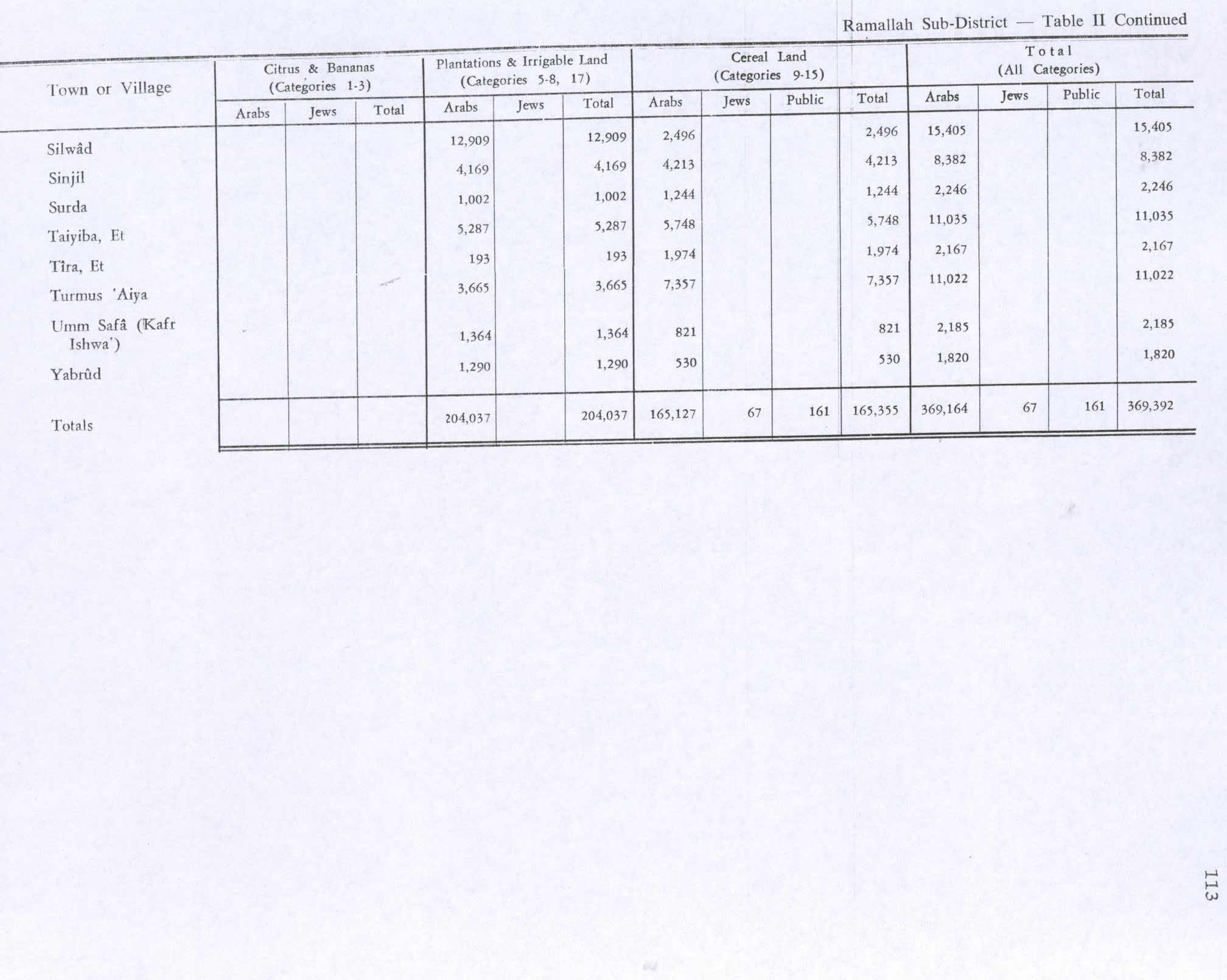
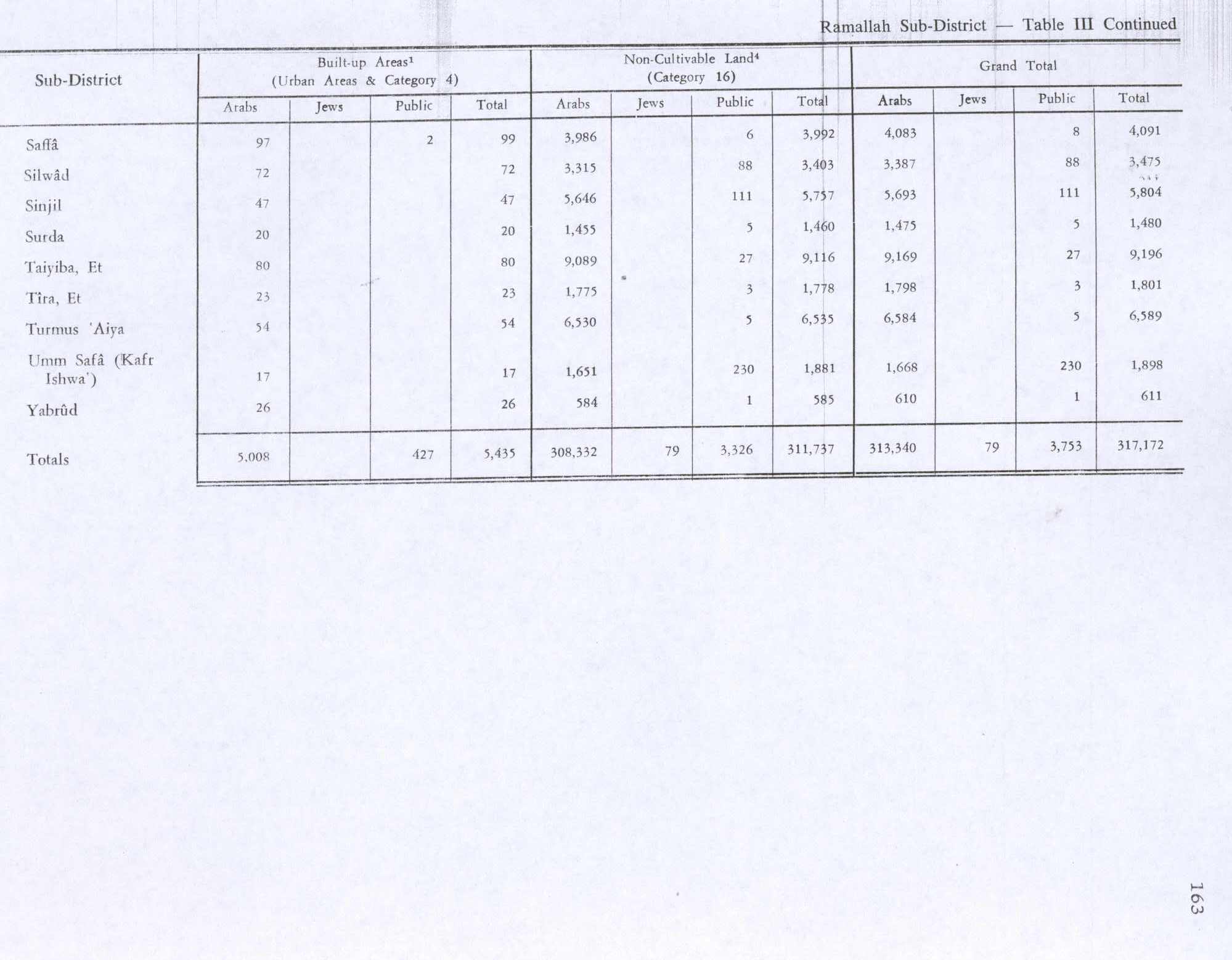
In the 1945 statistics the population of Surda was 250 Muslims,[12] while the total land area was 3,726 dunams, according to an official land and population survey.[13] Of this, 1,002 dunums were used for plantations and irrigable land, 1,244 for cereals,[14] while 20 dunams were classified as built-up areas.[15]
Jordanian era
In the wake of the 1948 Arab–Israeli War, and after the 1949 Armistice Agreements, Surda came under Jordanian rule.
The Jordanian census of 1961 found 415 inhabitants in Surda.[16]
1967-present
After the Six-Day War in 1967, Surda has been under Israeli occupation.
After the 1995 accords, 95.4% of village land has been defined as Area B land, while the remaining 4.6% is Area C.[17]
Surda is the birthplace of the Palestinian diplomat Hasan Abdel Rahman.
Footnotes
<templatestyles src="Reflist/styles.css" />
- ↑ Cite error: Script error: No such module "Namespace detect".Script error: No such module "Namespace detect".
- ↑ Cite error: Script error: No such module "Namespace detect".Script error: No such module "Namespace detect".
- ↑ a b Finkelstein et al, 1997, pp. 423-424
- ↑ Hütteroth and Abdulfattah, 1977, p. 117
- ↑ Robinson and Smith, 1841, vol 3, Appendix 2, p. 124
- ↑ Socin, 1879, p. 161. It was also noted to be in the Beni Harit district.
- ↑ Hartmann, 1883, p. 126 also noted 13 houses
- ↑ Conder and Kitchener, 1882, SWP II, p. 295. They further noted: "The name suggests its identity with Zereda, the native town of Jeroboam, (Script error: No such module "Bibleverse".)", but based on archeological evidence, Finkelstein et al, 1997, p. 424 thinks this is irrelevant.
- ↑ Schick, 1896, p. 123
- ↑ Barron, 1923, Table VII, Sub-district of Ramallah, p. 17
- ↑ Mills, 1932, p. 51.
- ↑ Government of Palestine, Department of Statistics, 1945, p. 26
- ↑ Government of Palestine, Department of Statistics. Village Statistics, April, 1945. Quoted in Hadawi, 1970, p. 65
- ↑ Government of Palestine, Department of Statistics. Village Statistics, April, 1945. Quoted in Hadawi, 1970, p. 113
- ↑ Government of Palestine, Department of Statistics. Village Statistics, April, 1945. Quoted in Hadawi, 1970, p. 163
- ↑ Government of Jordan, Department of Statistics, 1964, p. 24
- ↑ Surda Village Profile, ARIJ, p. 15
Script error: No such module "Check for unknown parameters".
Bibliography
<templatestyles src="Refbegin/styles.css" />
- Script error: No such module "citation/CS1".
- Script error: No such module "citation/CS1".
- Script error: No such module "citation/CS1".
- Script error: No such module "citation/CS1".
- Script error: No such module "citation/CS1".
- Script error: No such module "citation/CS1".
- Script error: No such module "Citation/CS1".
- Script error: No such module "citation/CS1".
- Script error: No such module "citation/CS1".
- Script error: No such module "citation/CS1".
- Script error: No such module "citation/CS1".
- Script error: No such module "Citation/CS1".
- Script error: No such module "Citation/CS1".
External links
- Surda genealogy: Family frees, Surda.net
- Welcome To Surda
- Survey of Western Palestine, Map 14: IAA, Wikimedia commons
- Surda (fact sheet), Applied Research Institute–Jerusalem (ARIJ)
- Surda Village Profile, ARIJ
- Surda (aerial photo), ARIJ
- Locality Development Priorities and Needs in Surda Village, ARIJ
Script error: No such module "Navbox". Template:Authority control