Sataf
Script error: No such module "Settlement short description".Script error: No such module "Infobox".Script error: No such module "Check for unknown parameters".Script error: No such module "Check for conflicting parameters".Expression error: Unexpected < operator Sataf (Arabic: صطاف, Hebrew: סטף) was a Palestinian village in the Jerusalem Subdistrict depopulated during the 1948 Arab–Israeli War. It was located 10 km west of Jerusalem, with Sorek Valley (Arabic: Wadi as-Sarar) bordering to the east.
Two springs, Ein Sataf and Ein Bikura flow from the site into the riverbed below.
A monastery located across the valley from Sataf, i.e. south of Wadi as-Sarar, known by local Arabs as Ein el-Habis (the "Spring of the Hermitage"), is officially called Monastery of Saint John in the Wilderness.
Today it is a tourist site showcasing ancient agricultural techniques used in the Jerusalem Mountains.
History
Chalcolithic period
Remains of a 4,000 BCE Chalcolithic village were discovered at the site. The related traces of agricultural activities number among the oldest in the region.[1]
Byzantine period
Most ancient remains date to the Byzantine period.[1]
Mamluk period
The first written mention of the site is from the Mamluk era.[1]
Ottoman period
Sataf was noted in the Ottoman tax records of 1525-1526 and 1538–1539, as being located in the Sanjak of Al-Quds.[2] According to archaeological work, the village originated in the late 16th century, with the use of several cave−dwellings. Later, houses were erected in front of the caves.[3]
In 1838 it was described as a Muslim village, located in the Beni Hasan district, west of Jerusalem.[4]
In 1863, Victor Guérin found a village of one hundred and eighty people. He further noted that their houses were standing on the slopes of a mountain, and that the mountainside was covered by successive terraces.[5] An Ottoman village list from about 1870 counted 38 houses and a population of 115, whereby only men were counted.[6][7]
In 1883, the Palestine Exploration Fund's Survey of Western Palestine described Setaf as "a village of moderate size, of stone houses, perched on the steep side of a valley. It has a spring lower down, on the north."[8]
In 1896 the population of Sataf was estimated to be about 180 persons.[9]
British Mandate period
By the 1922 census of Palestine conducted by the British Mandate authorities, Sataf had a population of 329; 321 Muslims and 8 Christians.[10] All the Christians were Roman Catholic.[11] The 1931 census lists 381 inhabitants; 379 Muslim and 2 Christian, in a total of 101 houses.[12]
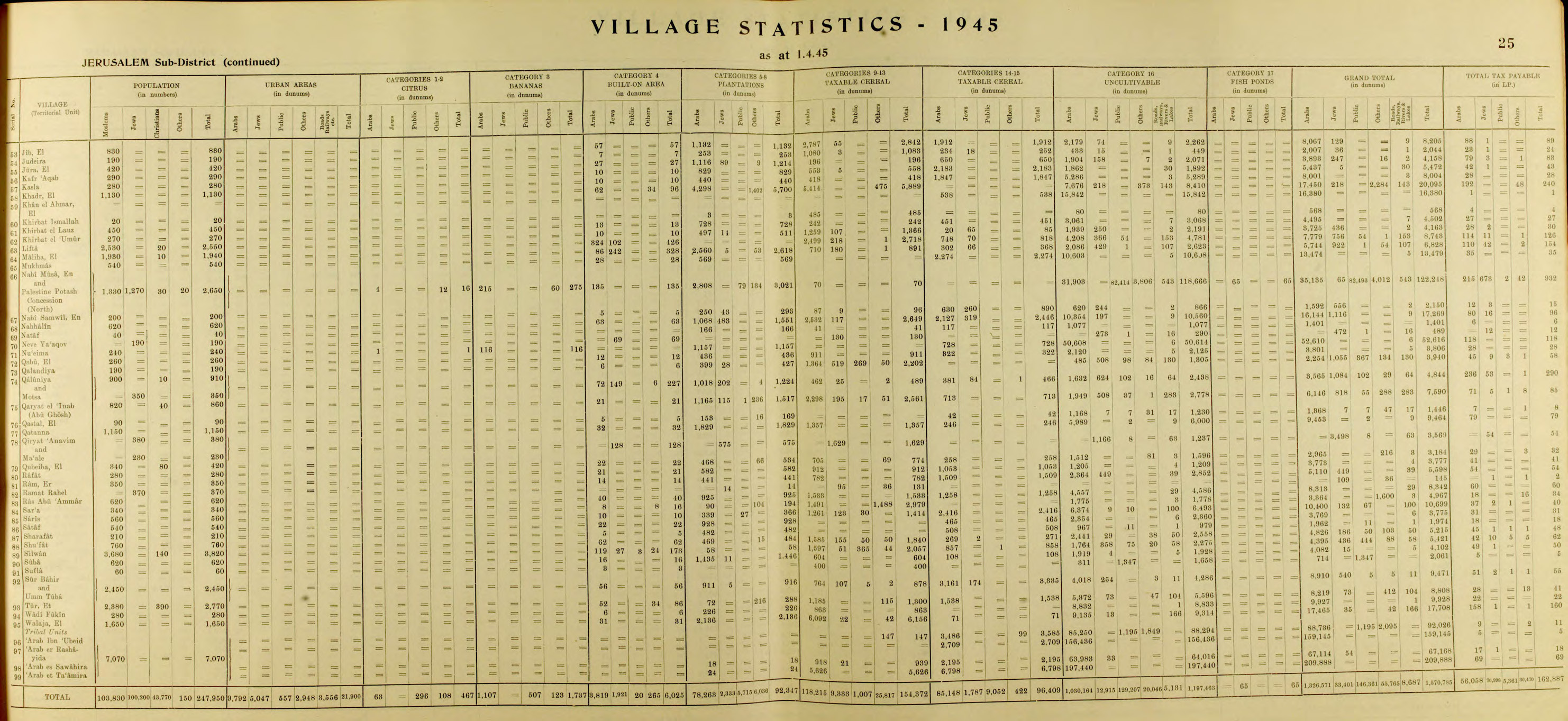
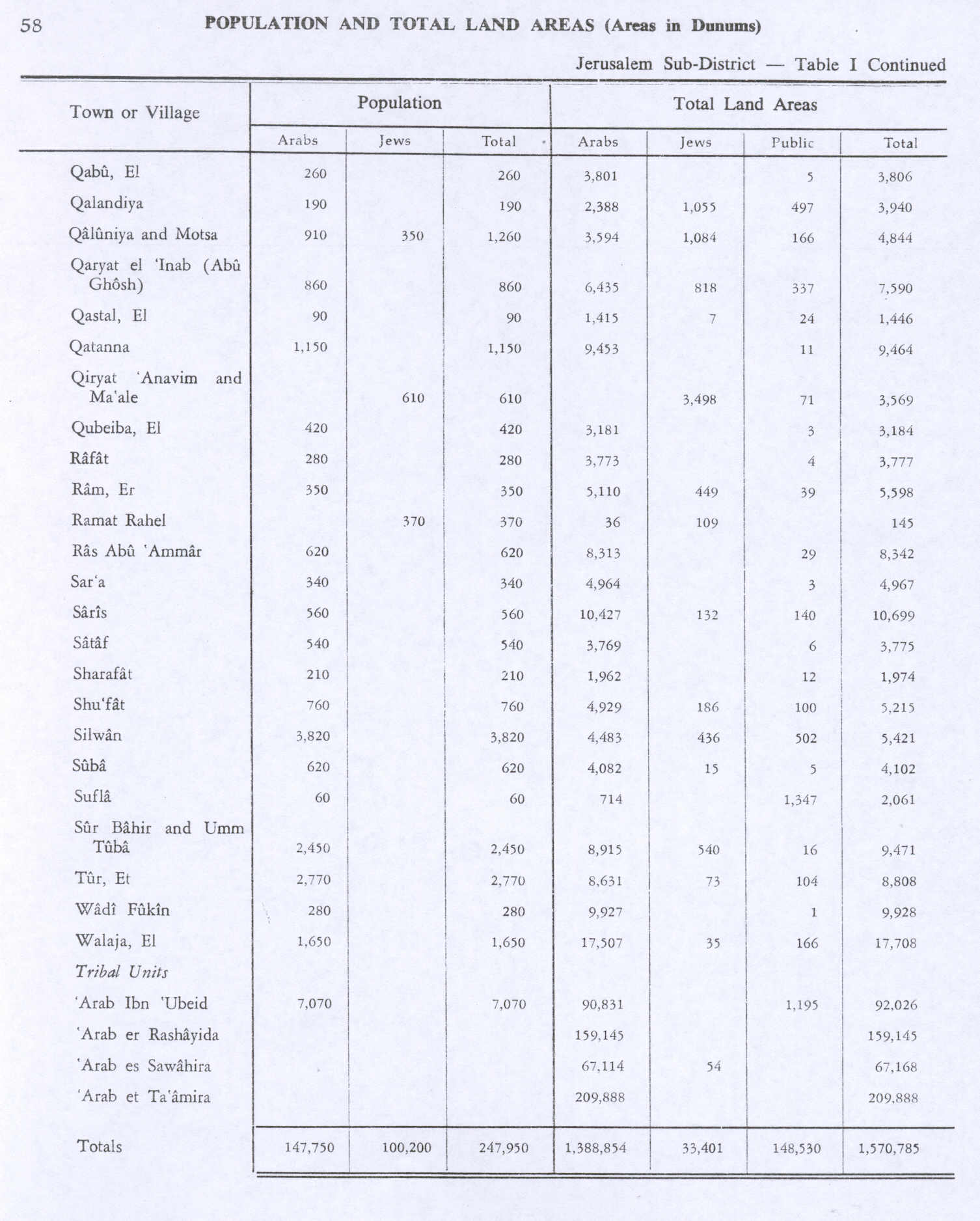
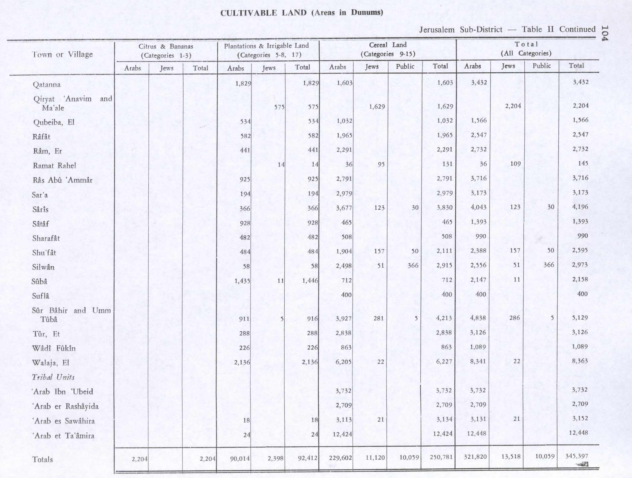
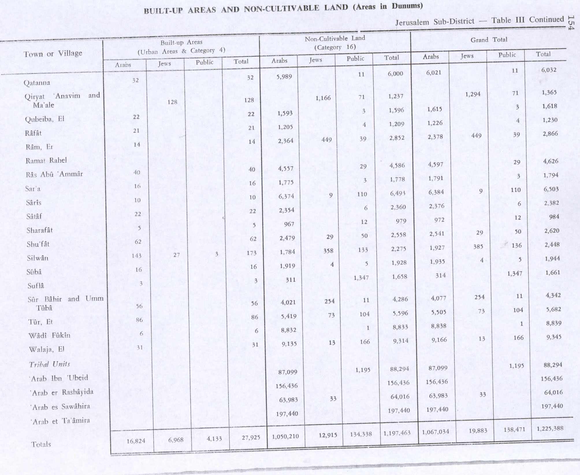
In the 1945 statistics the population of Sataf was 540, all Muslims,[13] and the total land area was 3,775 dunams, according to an official land and population survey.[14] Of this, 928 dunams were plantations and irrigable land, 465 for cereals,[15] while 22 dunams were built-up land.[16]
1948, aftermath
On July 13–14, 1948 the Arab village was depopulated by the Har'el Brigade, during Operation Danny.[17] Sataf and the surrounding area became part of the newly created State of Israel.
A short time after the 1948 War, a small group of Jewish immigrants from North Africa settled for a few months in the village area, calling it Bikura.[18] The village, which lasted only until the fall of 1950, was founded on the initiative of former Lehi commanded Natan Yellin-Mor.[18] Subsequently, the IDF's Unit 101 and paratroopers used the site for training purposes.[1]
In the 1980s the Jewish National Fund began the restoration of ancient agricultural terraces, and the area around the springs has been turned into a tourist site. A forest around the site was also planted by the Jewish National Fund.[19]
In 1992, Sataf was described as follows: "Many half-destroyed walls still stand, and some still have arched doorways. The walls of a few houses with collapsed roofs are almost intact....The area around the village spring, which is located to the east next to the ruins of a rectangular stone house, has been turned into an Israeli tourist site. A Jewish family has settled on the west side of the village, and have fenced in some of the village area."[17]
Shrine of 'Ubayd
The shrine (maqam) of 'Ubayd, southwest of the village site, contains a courtyard and three rooms.[3] According to Tawfiq Canaan, Sheikh 'Ubayd "is said to kill any goat or sheep who enters his cave."[20]
Gallery
-
The hill (jabal) across from Sataf. September 1, 1945.
-
Ein Sataf (Ein El-Balad), 2022
-
Ein Sataf, 2009
-
Ein Bikura (Ein E-Sharkia), 2022
-
Ein Bikura, 2009
-
Sataf reconstruction
-
Agriculture in Sataf, 2009
-
Remains of Sataf village


References
<templatestyles src="Reflist/styles.css" />
- ↑ a b c d Script error: No such module "citation/CS1".
- ↑ Toledano, 1984, pp. 280, 298. Toledano gives its location as 31°46′20″N 35°07′25″E
- ↑ a b Petersen, 2001, pp. 274−275
- ↑ Robinson and Smith, 1841, vol 3, Appendix 2, p. 123
- ↑ Guérin, 1869, pp. 3-4
- ↑ Socin, 1879, p. 160 also noted it was located in the Beni Hasan District
- ↑ Hartmann, 1883, p. 122, noted 40 houses
- ↑ Conder and Kitchener, 1883, SWP III, p. 22
- ↑ Schick, 1896, p. 125
- ↑ Barron, 1923, Table VII, Sub-district of Jerusalem, p. 14
- ↑ Barron, 1923, Table XVI, p. 45
- ↑ Mills, 1932, p. 43
- ↑ Government of Palestine, Department of Statistics, 1945, p. 25
- ↑ Government of Palestine, Department of Statistics. Village Statistics, April, 1945. Quoted in Hadawi, 1970, p. 58
- ↑ Government of Palestine, Department of Statistics. Village Statistics, April, 1945. Quoted in Hadawi, 1970, p. 104
- ↑ Government of Palestine, Department of Statistics. Village Statistics, April, 1945. Quoted in Hadawi, 1970, p. 154
- ↑ a b Khalidi, 1992, p. 317
- ↑ a b Script error: No such module "citation/CS1".
- ↑ Sataf from the Khalil Sakakini Cultural Center
- ↑ Canaan, 1927, p. 96
Script error: No such module "Check for unknown parameters".
Bibliography
<templatestyles src="Refbegin/styles.css" />
- Script error: No such module "citation/CS1".
- Script error: No such module "citation/CS1".
- Script error: No such module "citation/CS1".
- Script error: No such module "citation/CS1".
- Script error: No such module "citation/CS1".
- Script error: No such module "citation/CS1".
- Script error: No such module "Citation/CS1".
- Script error: No such module "citation/CS1".
- Script error: No such module "citation/CS1".
- Script error: No such module "citation/CS1".
- Script error: No such module "citation/CS1".
- Script error: No such module "citation/CS1".
- Script error: No such module "citation/CS1".
- Script error: No such module "Citation/CS1".
- Script error: No such module "Citation/CS1".
- Script error: No such module "Citation/CS1".
External links
Script error: No such module "Side box".
- Welcome To Sataf in Palestineremembered.com
- Sataf, from Zochrot
- Survey of Western Palestine, Map 17: IAA, Wikimedia commons
- Map, 1946

Template:Palestinian Arab villages depopulated during the 1948 Palestine War