Perdido Pass

Script error: No such module "Location map".
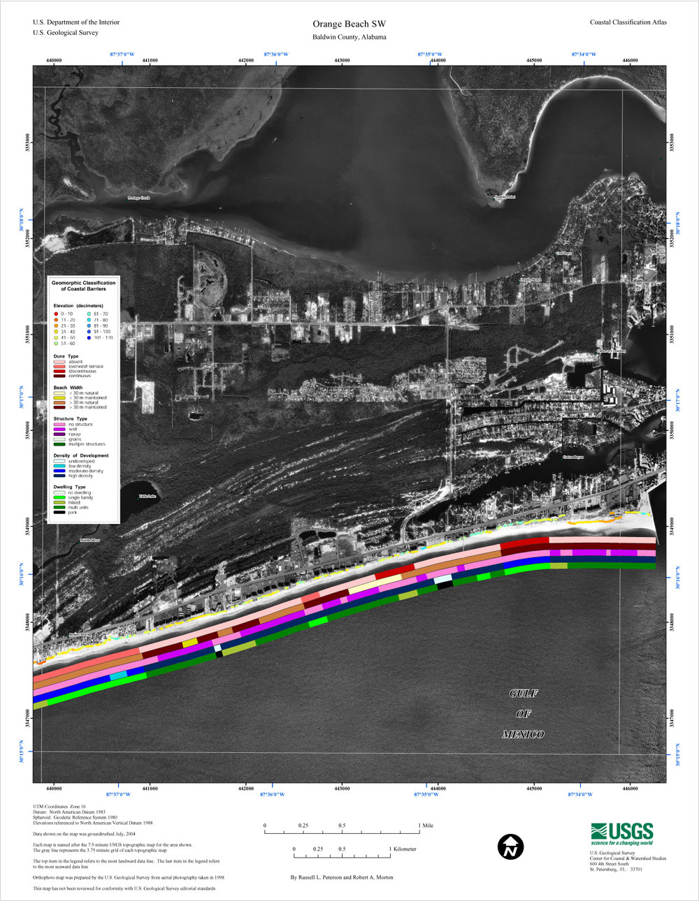
Perdido Pass, separating Alabama Point from Florida Point, is the mouth of the Perdido River. Perdido Pass forms a water passage that connects Perdido Bay with the Gulf of Mexico to the south, in the U.S. state of Alabama, 2 miles (3 km) west of the Alabama/Florida state line. A bridge spans Perdido Pass, connecting Alabama Point (western side) with Florida Point in Alabama (linked below). At the entrance into the Gulf, the 2 rock barriers, extending from the white beaches, are the west jetty & east jetty (see image). The surrounding area is heavily developed, with high-rise condominiums. However, there are nearby beach-front parks, with Gulf State Park on the eastern side of Perdido Pass.[1]
Description
Perdido Pass, extending between Florida Point and Alabama Point, is easily distinguished, from offshore, by the Alabama State Route 182 highway bridge in Orange Beach, Alabama, spanning the pass with two openings. The fixed span over Perdido Pass Channel has a clearance of Script error: No such module "convert".. The fixed span over Cotton Bayou Channel has a clearance of Script error: No such module "convert".. The dredged entrance channel leads from the Gulf through Perdido Pass to a fork at the highway bridge; thence into two channels, one leading north into Terry Cove and Johnson Cove and the other leading east into Bayou St. John. The entrance to the pass is protected by a jetty on the west and by a combination weir and jetty on the east; the top of the weir is submerged Script error: No such module "convert". at mean low tide. Numerous sunken wrecks are in the approach to the pass.
History
The Perdid Pass was about Script error: No such module "convert". east of its present location until early in the 20th century. The barrier spit on the western (Alabama) side of the inlet, Point Ornocor, overlapped what is now Perdido Key, extending for several miles parallel to and on the north side of Perdido Key. As a result, the water passage from Perdido Pass to Perdido Bay was long, narrow and winding, passing between Perdido Key and Point Orconor, doubling the end of the point and then passing back between the point and the Florida shore on the north side. In early 1906, local residents dug a new inlet through Point Ornocor about Script error: No such module "convert". west of the old inlet. The new inlet was widened by the 1906 Mississippi hurricane. The old inlet then silted up and closed, with the result that the portion of Point Ornocor east of the new inlet was attached to Perdido Key and the Florida mainland. The original waterway from the old Perdido Pass to Perdido Bay became known as Old River. A passage later opened from the western end of Old River to the Bayou St. John near the new Perdido Pass, separating what is now Ono Island from Perdido Key. The spit ending on the west side of Perdido Pass is now known as Alabama Point. Alabama and Florida settled the location of the state line in 1953, placing it at the location of the old Perdido Pass.Script error: No such module "Footnotes".Script error: No such module "Check for unknown parameters".Script error: No such module "Footnotes".Script error: No such module "Check for unknown parameters". Perdido Pass has historically moved westward due to longshore drift. The westward flowing longshore current accretes sand on the up-current (eastern) side of the pass and erodes sand from the down-current (western) side.Script error: No such module "Footnotes".Script error: No such module "Check for unknown parameters".
Depth of channels

In October 2006, the controlling depth was Script error: No such module "convert"., reaching Script error: No such module "convert". at mid-channel, in the entrance channel to the intersection of the east and west channels. From that area, thence Script error: No such module "convert"., reaching Script error: No such module "convert". at mid-channel, in the west channel leading to Terry and Johnson Coves, thence Script error: No such module "convert"., reaching Script error: No such module "convert". at mid-channel, in the east channel leading to Bayou St. John. The channels are well marked. A lighted whistle buoy off the entrance marks the approach.
Access to the Intracoastal Waterway
The Intracoastal Waterway, in the lower part of Perdido Bay, is reached from Perdido Pass via a marked channel through Bayou St. John. In May 1982, shoaling to Script error: No such module "convert". was reported in Bayou St. John, between day-beacons no. 6 and 8. An overhead power cable, with a clearance of Script error: No such module "convert"., crosses the channel leading to Terry Cove and Johnson Cove, about Script error: No such module "convert". from the State Route 182 fixed bridge. Several small-craft facilities are in the coves and Cotton Bayou, on the W side of Perdido Pass Script error: No such module "convert". above the entrance.
Old River

Script error: No such module "Location map". Old River enters Perdido Pass from the east between Florida Point and Ono Island. In May 1982, a reported depth of Script error: No such module "convert". could be carried through the river, with local knowledge. The Florida-Alabama state boundary passes along the center of Old River until 2 miles (3 km) before Perdido Pass. A fixed highway bridge with a clearance of Script error: No such module "convert". crosses Old River, about Script error: No such module "convert". east of Perdido Pass.[2]
Florida Point in Alabama
Both Alabama Point and Florida Point are in the town of Orange Beach, Alabama (along the Gulf of Mexico).[3] However, Florida Point is the tip of a peninsula originating in the U.S. State of Florida, with the final 2 miles (3 km) of the tip contained within Alabama. Often, U.S. state lines run through the middle of a water pass or river; however, Perdido Pass is entirely within the State of Alabama, and the state line runs east of it. The Gulf State Park is located on Florida Point. Historically, new passes are breached and old ones filled in during hurricanes. The original pass discovered by Juan Carlos Siquenza (sp?)was located on the current state boundary between Alabama, and Florida. The use of stone and cement jetties combined with dredging and pumping sand out of the pass by the Army Corps of Engineers and the City of Orange Beach currently mitigates damage from hurricanes and sedimentation.
Islands of Perdido Pass
Also known as the Orange Beach Islands, the Islands of Perdido Pass are considered both recreational hangouts for boaters, and vital sanctuaries to several species of plant and animal. The islands of Orange Beach, Alabama are accessible only by watercraft. Two public boat accesses are offered in Orange Beach, as well as boat launches including The Wharf or Bear Point Marina.[4]
The Islands of Perdido Pass consist of Bird Island, Robinson Island, Gilchrist Island, Walker Island, and the easternmost Rabbit Island.[5]
2010 Deepwater Horizon oil spill
Following the 2010 Deepwater Horizon oil spill the entrance to Perdido Pass was closed, with a barrier system in June 2010, to control tidal flow of oil entering from the Gulf of Mexico. The daily high tide was causing oil-contaminated water to enter Perdido Bay. The barrier system was designed to allow boats to travel through Perdido Pass, during the outflowing tide, but close during the rising tide and collect oil deposits in a retention area on the eastern edge of the pass. During the disaster BP took over much of the Gulf State Park and used it for parking or storage of equipment. As of April 2011, BP or BP subcontractors were still utilizing the park free of charge.
East of Mobile Bay the damage to the fragile environment from BP oil spill clean-up crews exceeded damage done by the oil spill itself.[6]
References
<templatestyles src="Reflist/styles.css" />
- ↑ "Orange Beach SW" (area map showing development), USGS, 5 May 2005, web image: USGS-map.
- ↑ Office of Coast Survey - United States Coast Pilot 5
- ↑ See Google maps of area: Map-around-Perdido-Pass.
- ↑ Orange Beach Islands, Retrieved May 20th, 2016.
- ↑ Islands of Perdido Foundation, Retrieved May 20th, 2016.
- ↑ Script error: No such module "citation/CS1".
Script error: No such module "Check for unknown parameters".
Sources
- Script error: No such module "citation/CS1".
- Script error: No such module "citation/CS1".
- Script error: No such module "citation/CS1".
Template:Deepwater Horizon oil spill Script error: No such module "Authority control".
Script error: No such module "Coordinates".