Mount Tammany
Template:Short description Template:Use mdy dates Template:Infobox mountain
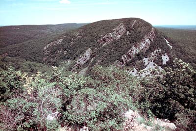
Mount Tammany is the southernmost peak of the Kittatinny Mountains, in Knowlton Township, Warren County, New Jersey, United States. It is Script error: No such module "convert". tall, and forms the east side of the Delaware Water Gap. Across the Gap is Mount Minsi, on the Pennsylvania side of the river. The mountain is named after the Lenni Lenape chief Tamanend.[1] It lies along the Appalachian Trail in Worthington State Forest. The summit can be hiked by the Mount Tammany Trail ascending the western slopes.[2] The trailhead is accessible from Interstate 80.
Script error: No such module "wide image".Script error: No such module "Check for unknown parameters".
Trails and hiking
Hiking on Mount Tammany consists of two trails: the red dot trail and the blue dot trail. The red dot trail is 1.2 miles and the blue dot trail is 1.8 miles. Combining the two for one of NJ's most popular hikes is a 3 mile loop. There is a 1201 feet elevation change going up and down the mountain. Generally, this is considered a challenging trail with an average completion time of 2 hours 20 minutes. Climbing up the trail also requires bouldering and physical climbing at some points along the trail. Recommended equipment, comfortable, active footwear, water, appropriate clothing for physical activity.Script error: No such module "Unsubst".
References
<templatestyles src="Reflist/styles.css" />
Script error: No such module "Check for unknown parameters".
External links
Template:Delaware Water Gap National Recreation Area Template:Mountains of New Jersey