Far'un
Template:Pp-extended Script error: No such module "Settlement short description".Script error: No such module "Infobox".Template:Template otherScript error: No such module "Check for unknown parameters".Script error: No such module "Check for conflicting parameters".Expression error: Unexpected < operator. Far'un (Template:Langx) is a Palestinian town in the Tulkarm Governorate in the northwestern West Bank, located four kilometers south of Tulkarm near the border with Israel. According to the Palestinian Central Bureau of Statistics, Far'un had a population of 3,100 inhabitants in 2007 and 4,131 by 2017.[1][2]
History
In 1265, Far'un was among the villages and estates sultan Baibars allocated to his amirs after he had expelled the Crusaders. Half of the income from Far'un went to his emir Saif al-Din Dakhak al-Baghdadi, the other half to his emir Alam al-Din Sanjar al-Azkashi.[3]
In 1320, Far'un is shown by Marino Sanuto on his map from that year as Farona.[4]
Ottoman era
Far'un was incorporated into the Ottoman Empire in 1517 with all of Palestine, and in 1596 it appeared in the tax registers as being in the Nahiya of Bani Sa'b of the Liwa of Nablus. It had a population of 23 households, all Muslims. The villagers paid a fixed tax rate of 33,3% on various agricultural products, such as wheat, barley, fruit trees, goats and/or beehives, in addition to "occasional revenues"; a total of 3,837 akçe. 9/24 of the revenues went to a waqf.[5]
Far'un was marked as a village named "Faroun" on Pierre Jacotin's map surveyed during Napoleon's 1799 invasion.[6] In 1838, Fer'on was noted as a Greek Christian village in the Beni Sa'ab area, west of Nablus.[7]
In 1870, the French explorer Victor Guérin noted that it was situated on a hill, and contained 500 inhabitants.[8] In 1870/1871 (1288 AH), an Ottoman census listed the village in the nahiya (sub-district) of Bani Sa'b.[9]
In 1882, the PEF's Survey of Palestine (SWP) described it as "a small village on a slope, at the edge of the plain, with a few trees and a well to the east. The inhabitants are Greek Christians. [..] The name means "Pharaoh" but may perhaps be a corruption of Pharathoni or Pirathion."[4]
British Mandate era
In the 1922 census of Palestine conducted by the British Mandate authorities, Far'un had a population of 341, all Muslims,[10] increasing by the 1931 census to 456, 450 Muslims and 6 Christians, in 107 houses.[11]
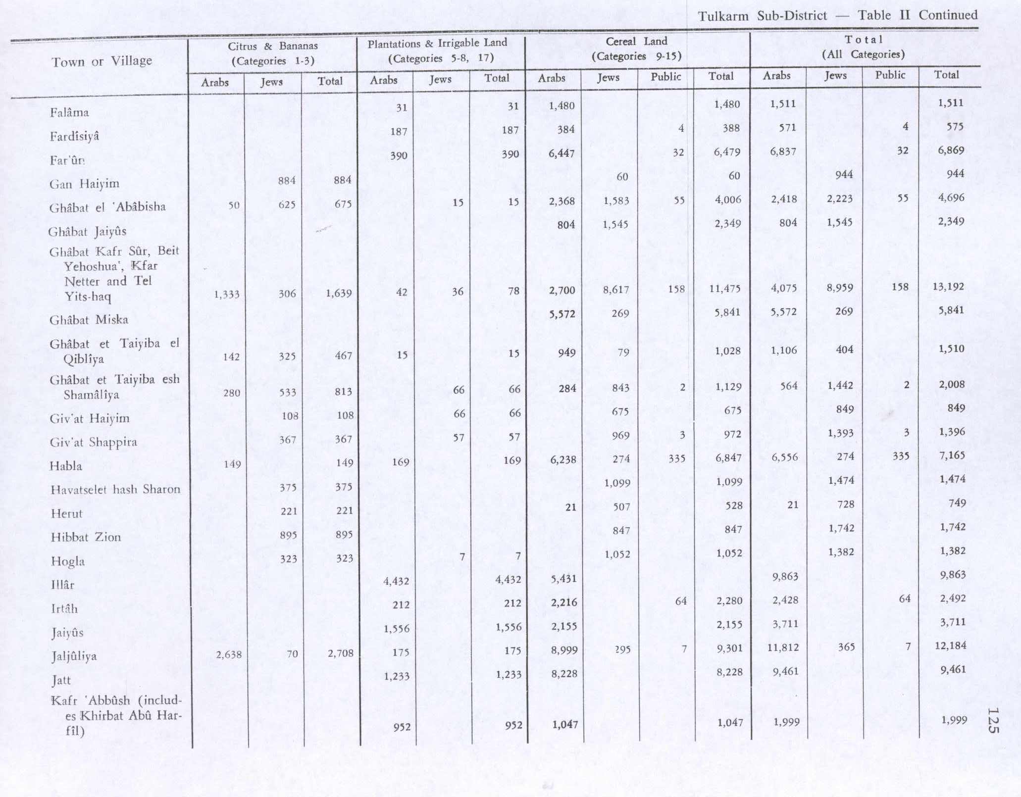
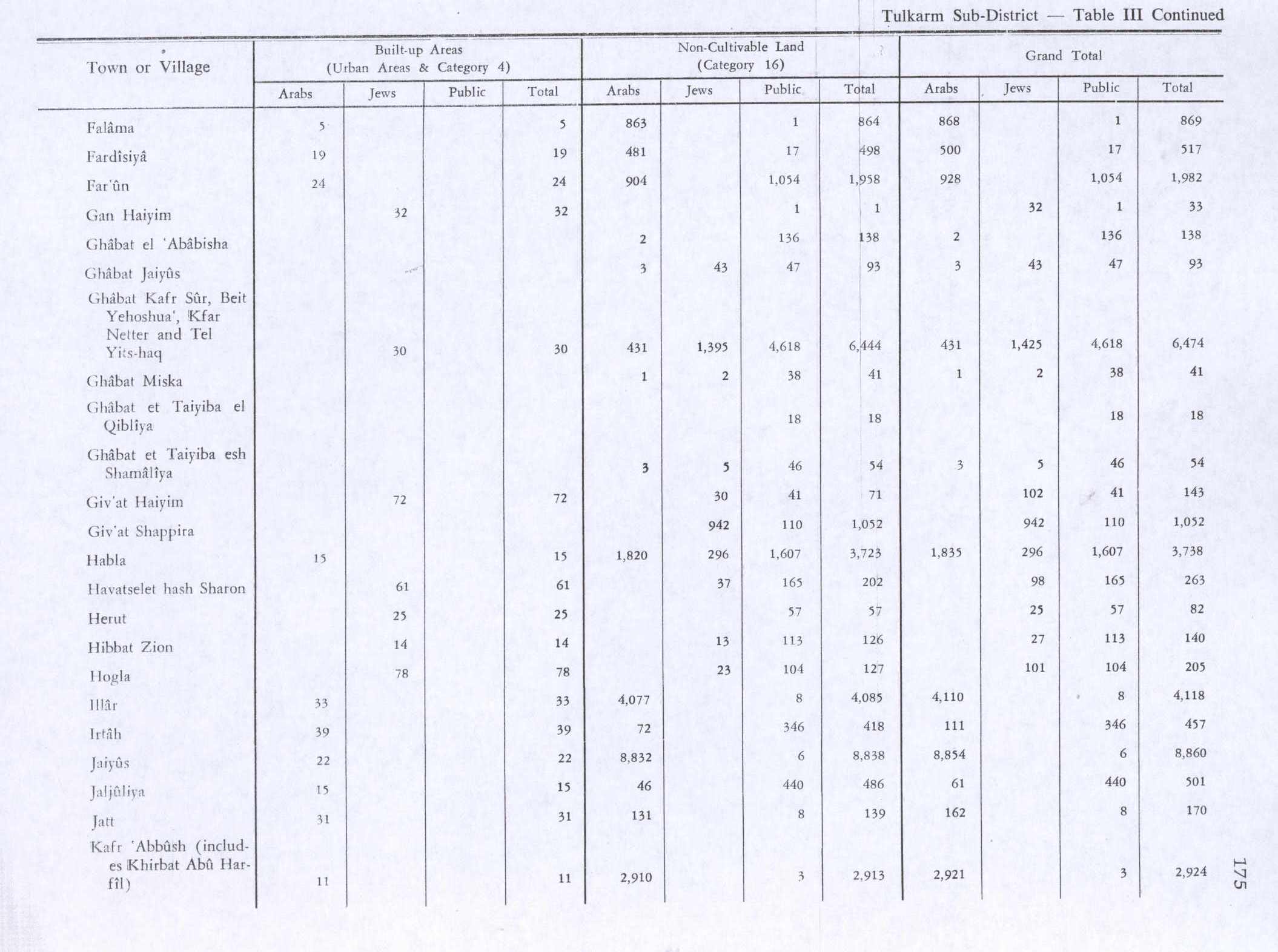
In the 1945 statistics the population of Far'un was 710, 700 Muslims and 10 Christians,[12] and the land area was 8,851 dunams, according to an official land and population survey.[13] 390 dunams were plantations and irrigable land, 6,479 used for cereals,[14] while 24 dunams were built-up (urban) land.[15]
-
Far'un 1942 1:20,000, including Irtah
-
Far'un 1945 1:250,000
Jordanian era
After the 1948 Arab–Israeli War and the 1949 Armistice Agreements, Far'un came under Jordanian rule.
In 1961, the population was 1,093.[16]
Post-1967
.jpg)
During the Six-Day War in 1967, Far'un came under Israeli occupation and has remained so since. The total land area of the town 8,800 dunams, however nearly half of Far'un's land has been confiscated by Israeli authorities. It currently has a land area of 4,333 dunams of which 495 is built-up area.[17] About 70% of the town's land is planted with olive groves, 5% is cultivated with citrus, guava and almond trees.[18]
Most of the town's labor force is employed in agriculture or work inside Israel.[18] Far'un is governed by a Village Council and contains 3 mosques, 3 schools, a medical clinic and a child care center.[19]
Nufs Jebil
Script error: No such module "about". 1.5 km SE of Far'un village centre lies Nufs Jebil.[20][21] Nisf Jubeil was a Crusader casale named Seingebis belonging to the territory of Caesarea in the early 13th-century. In 1207 Lady Juliana of Caesarea granted Seingebis along with nearby Far'un to the Knights Hospitallers.[22][23] In 1882, SWP found "Foundations on a hill" here.[24]
References
<templatestyles src="Reflist/styles.css" />
- ↑ Cite error: Script error: No such module "Namespace detect".Script error: No such module "Namespace detect".
- ↑ 2007 PCBS census Template:Webarchive Palestinian Central Bureau of Statistics (PCBS). p. 108.
- ↑ Ibn al-Furat, 1971, pp. 81, 209, 249 (map)
- ↑ a b Conder and Kitchener, 1882, SWP II, p. 164
- ↑ Hütteroth and Abdulfattah, 1977, p. 139
- ↑ Karmon, 1960, p. 170 Template:Webarchive
- ↑ Robinson and Smith, 1841, vol 3, Appendix 2, p. 128
- ↑ Guérin, 1875, p.352
- ↑ Script error: No such module "citation/CS1".
- ↑ Barron, 1923, Table IX, Sub-district of Tulkarem, p. 27
- ↑ Mills, 1932, p. 54
- ↑ Government of Palestine, Department of Statistics, 1945, p. 20
- ↑ Government of Palestine, Department of Statistics. Village Statistics, April, 1945. Quoted in Hadawi, 1970, p. 74
- ↑ Government of Palestine, Department of Statistics. Village Statistics, April, 1945. Quoted in Hadawi, 1970, p. 125
- ↑ Government of Palestine, Department of Statistics. Village Statistics, April, 1945. Quoted in Hadawi, 1970, p. 175
- ↑ Government of Jordan, 1964, p. 27
- ↑ Closure of an agricultural Wall gate threatens the olive-picking season in Far'un village Template:Webarchive Land Research Center. 18 September 2006.
- ↑ a b Effects of the Segregation Wall and Israeli military garrison on the Palestinian village of Faro'un / Tulkarm governorate Template:Webarchive Land Research Center. 6 September 2003.
- ↑ Far'un PalestineRemembered. Template:In lang
- ↑ grid no.: 1536/1872, according to Pringle, 1986, p. 41
- ↑ "The watershed"; according to Palmer, 1881, p. 189
- ↑ Boas, 2006, p. 82, citing Röhricht, 1893, RHH p. 220, no. 818
- ↑ Clermont-Ganneau, 1888, pp. 335, 401, cited in Röhricht, 1893, RRH, p. 205, No. 768
- ↑ Conder and Kitchener, 1882, SWP II, p. 210
Script error: No such module "Check for unknown parameters".
Bibliography
<templatestyles src="Refbegin/styles.css" />
- Script error: No such module "citation/CS1".
- Script error: No such module "citation/CS1".
- Script error: No such module "citation/CS1".
- Script error: No such module "citation/CS1".
- Script error: No such module "citation/CS1".
- Script error: No such module "citation/CS1".
- Script error: No such module "citation/CS1".
- Script error: No such module "citation/CS1".
- Script error: No such module "citation/CS1".
- Script error: No such module "citation/CS1".
- Script error: No such module "Citation/CS1".
- Script error: No such module "citation/CS1".
- Script error: No such module "citation/CS1".
- Script error: No such module "citation/CS1".
- Script error: No such module "citation/CS1".
- Script error: No such module "citation/CS1".
External links
- Welcome To Far'un
- Survey of Western Palestine, Map 11: IAA, Wikimedia commons
- Jacotin, map #45
Script error: No such module "Navbox". Template:Authority control