Al-Judeira
Template:Pp-extended Script error: No such module "Settlement short description".Script error: No such module "Infobox".Template:Template otherScript error: No such module "Check for unknown parameters".Script error: No such module "Check for conflicting parameters".Expression error: Unexpected < operator. Al-Judeira (Template:Langx) is a Palestinian village in the Jerusalem Governorate of the State of Palestine, in the central West Bank.
According to the Palestinian Central Bureau of Statistics, the town had a population of 2,634 in 2017.[1]
Toponymy
E. H. Palmer of the Palestine Exploration Fund wrote that Al-Judeira means "sheep-fold", after the Template:Langx, "fold".[2]
Location
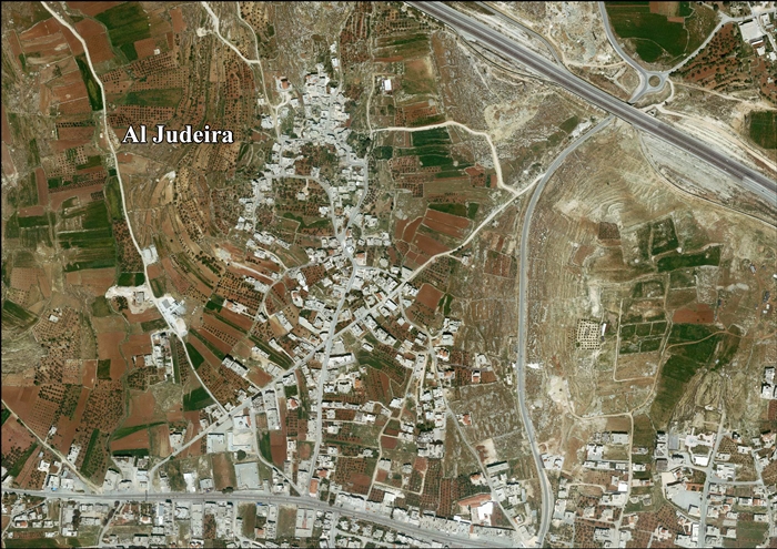
Al Judeira is located (horizontally) Script error: No such module "convert". north-west of Jerusalem. To the east is Kalandia, Rafat is to the north, Al Jib is to the west, and Bir Nabala is to the south.[3]
History
Ancient period
Several scholars have suggested that Judeira is the site of Gederah in Benjamin, which is mentioned in the Bible as home to Yozabad the Gederathite, a Benjaminite warrior who defected to David. It is mentioned shortly after the nearby sites of Azmaveth (identified with modern-day Hizme), Anathoth (probably 'Anata) and Gibeon (Al Jib).[4][5][6]
Ottoman era
In the Ottoman census of the 1500s, Jadira was noted as a village located in the nahiya of Jerusalem.[7]
In 1838 el-Jedireh was noted as a Muslim village, located north of Jerusalem.[8][9]
In 1863 Guérin described it as a small village, with a mosque consecrated to a Sheikh Yassin. In the courtyard in front of this sanctuary, he noticed what was possibly an old Corinthian capital, which had been made into a mortar, where the villagers pounded coffee.[10] An Ottoman village list from about 1870 found that the village had a population of 40, in a total of 13 houses, though the population count only included men. It was also noted that it was located east of Al Jib.[11][12]
In 1883, the PEF's Survey of Western Palestine (SWP) described it as "a small village on a slope, surrounded by figs and olives, and with rock-cut tombs to the north."[4]
British Mandate era
In the 1922 census of Palestine conducted by the British Mandate authorities, Ijdireh had a population of 122, all Muslims,[13] increasing in the 1931 census to 139 Muslim inhabitants, in 31 inhabited houses.[14]
In the 1945 statistics Judeira had a population of 190 Muslims,[15] with 2,044 dunams of land, according to an official land and population survey.[16] Of this, 353 dunams were plantations and irrigable land, 1,314 used for cereals,[17] while 7 dunams were built-up (urban) land.[18]
Jordanian era
In the wake of the 1948 Arab–Israeli War, and after the 1949 Armistice Agreements, al-Judeira came under Jordanian rule.
The Jordanian census of 1961 found 328 inhabitants in Judeira.[19]
Post-1967
Since the Six-Day War in 1967, al-Judeira has been under Israeli occupation.
After the 1995 accords, 25.4% of the village’s land was classified as Area B, the remaining 74.6% is classified was Area C.[20]
In 2005, Israel started the construction of a separation barrier around al-Judeira, Al Jib, Bir Nabala, Beit Hanina al-Balad and Kalandiya.[21] The wall was built on Palestinian land seized by Military Orders.[22] The wall completely surrounds the villages, forming an enclave.[23]
References
<templatestyles src="Reflist/styles.css" />
- ↑ Cite error: Script error: No such module "Namespace detect".Script error: No such module "Namespace detect".
- ↑ Cite error: Script error: No such module "Namespace detect".Script error: No such module "Namespace detect".
- ↑ Al Judeira Village Profile, ARIJ, p. 4
- ↑ a b Conder and Kitchener, 1883, SWP III, pp. 9 10
- ↑ Script error: No such module "Citation/CS1".
- ↑ Script error: No such module "citation/CS1".
- ↑ Toledano, 1984, p. 294, has Jadira at location 35°11′35″E 31°51′35″N.
- ↑ Robinson and Smith, 1841, vol 3, Appendix 2, p. 122
- ↑ Robinson and Smith, 1841, vol 2, p. 137
- ↑ Guérin, 1868, p. 392
- ↑ Socin, 1879, p. 153
- ↑ Hartmann, 1883, p. 127, noted 17 houses
- ↑ Barron, 1923, Table VII, Sub-district of Jerusalem, p. 15
- ↑ Mills, 1932, p. 40
- ↑ Government of Palestine, Department of Statistics, 1945, p. 25
- ↑ Government of Palestine, Department of Statistics. Village Statistics, April, 1945. Quoted in Hadawi, 1970, p. 57 Template:Webarchive
- ↑ Government of Palestine, Department of Statistics. Village Statistics, April, 1945. Quoted in Hadawi, 1970, p. 103 Template:Webarchive
- ↑ Government of Palestine, Department of Statistics. Village Statistics, April, 1945. Quoted in Hadawi, 1970, p. 153 Template:Webarchive
- ↑ Government of Jordan, Department of Statistics, 1964, p. 23
- ↑ Al Judeira Village Profile, ARIJ, p. 17
- ↑ High Court approves Bir Nabalah enclave. B'Tselem, 26 November 2006
- ↑ Israel’s Segregation Wall Encircles Three Palestinian Villages in Northwest Jerusalem Template:Webarchive ARIJ, 7 May 2005
- ↑ Script error: No such module "citation/CS1".
Script error: No such module "Check for unknown parameters".
Bibliography
<templatestyles src="Refbegin/styles.css" />
- Script error: No such module "citation/CS1".
- Script error: No such module "citation/CS1". (p. 43)
- Script error: No such module "citation/CS1".
- Script error: No such module "citation/CS1".
- Script error: No such module "citation/CS1".
- Script error: No such module "citation/CS1".
- Script error: No such module "Citation/CS1".
- Script error: No such module "citation/CS1".
- Script error: No such module "citation/CS1".
- Script error: No such module "citation/CS1".
- Script error: No such module "citation/CS1".
- Script error: No such module "Citation/CS1".
- Script error: No such module "Citation/CS1".
External links
- Welcome To Judayra
- Survey of Western Palestine, Map 17: IAA, Wikimedia commons
- Al Judeira Village (Fact Sheet), Applied Research Institute–Jerusalem (ARIJ)
- Al Judeira Village Profile, ARIJ
- Al Judeira area photo, ARIJ
- Locality Development Priorities and Needs in Al Judeira, ARIJ
Script error: No such module "Navbox".