Tinaroo, Queensland
Script error: No such module "redirect hatnote". Template:Use dmy dates Template:Use Australian English Template:Side box Script error: No such module "infobox".Script error: No such module "Check for unknown parameters". Tinaroo is a rural locality in the Tablelands Region, Queensland, Australia.[2] In the Template:CensusAU, Tinaroo had a population of 293 people.[1]
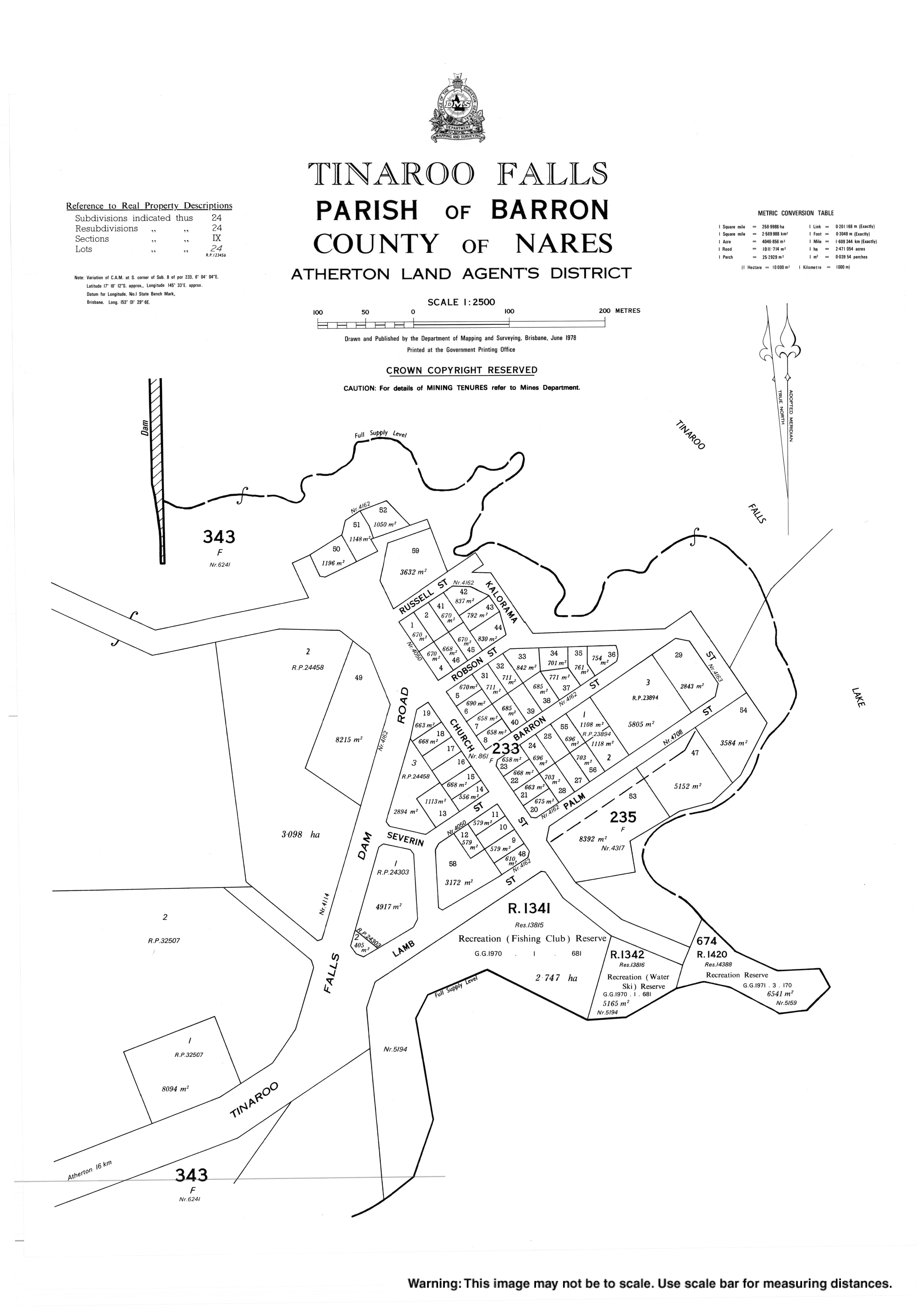
The town of Tinaroo Falls is on the eastern edge of the locality (Script error: No such module "Coordinates".) beside Lake Tinaroo.[3]
Geography
Tinaroo is located on the shore of Lake Tinaroo, a man-made reservoir created by the impoundment of the Barron River by the Tinaroo Dam.[4]
Despite the town's name, the waterfall of the same name is not in the town nor the locality, but it is very close by in the neighbouring locality of Lake Tinaroo, which includes the dam wall, the lake it impounds and the shoreline around the lake.[5]
History
The town and locality take their name from Tinaroo Creek, which is believed to derive from tin hurroo, a shout used by tin miners.[3]
Construction of the dam commenced in 1955 and the town was created to house the workers and their families. Tinaroo State School opened on 28 June 1954 for the workers' children. Construction completed in 1958 and the school closed on 4 December 1959.[6][7]
Tinaroo Environmental Education Centre was established in 1987.[8]
Demographics
In the Template:CensusAU, Tinaroo had a population of 266 people.[9]
In the Template:CensusAU, Tinaroo had a population of 312 people.[10]
In the Template:CensusAU, Tinaroo had a population of 293 people.[1]
Education
Tinaroo Environmental Education Centre is 30-44 Tinaroo Falls Dam Road (Script error: No such module "Coordinates".). Operated by the Queensland Education Department, it provides outdoor and environment school programs.[11]
There are no mainstream schools in Tinaroo. The nearest government primary school is Kairi State School in neighbouring Kairi to the south. The nearest government secondary school is Atherton State High School in Atherton to the south-west.[12]
Attractions
Torpedo Bay Walking Track commences 2.3 km north of the dam wall and includes six lookouts.[13][14]
Platypus Rock Lookout is accessed from the Platypus Campground Road (Script error: No such module "Coordinates".).[13]
There is a boat ramp in Church Street providing access to the lake (Script error: No such module "Coordinates".). It is managed by the Tablelands Regional Council.[15]
References
<templatestyles src="Reflist/styles.css" />
- ↑ a b c Template:Census 2021 AUS
- ↑ Template:Cite QPN
- ↑ a b Template:Cite QPN
- ↑ Script error: No such module "citation/CS1".
- ↑ Template:Cite QPN
- ↑ Script error: No such module "citation/CS1".
- ↑ Script error: No such module "citation/CS1".
- ↑ Script error: No such module "citation/CS1".
- ↑ Script error: No such module "citation/CS1".
- ↑ Template:Census 2016 AUS
- ↑ Script error: No such module "citation/CS1".
- ↑ Template:Queensland Globe
- ↑ a b Script error: No such module "citation/CS1".
- ↑ Script error: No such module "citation/CS1".
- ↑ Script error: No such module "citation/CS1".
Script error: No such module "Check for unknown parameters".
External links
- Script error: No such module "citation/CS1".
- Town map of Tinaroo Falls, 1978
Template:Tablelands Region Script error: No such module "Navbox". Template:Authority control