Tallapoosa County, Alabama
Template:Short description Template:Use American English Template:Use mdy dates Script error: No such module "Settlement short description".Script error: No such module "Infobox".Template:Template otherScript error: No such module "Check for unknown parameters".Script error: No such module "Check for conflicting parameters".Expression error: Unexpected < operator.Template:Category handlerExpression error: Unrecognized punctuation character "[".Script error: No such module "Check for unknown parameters".
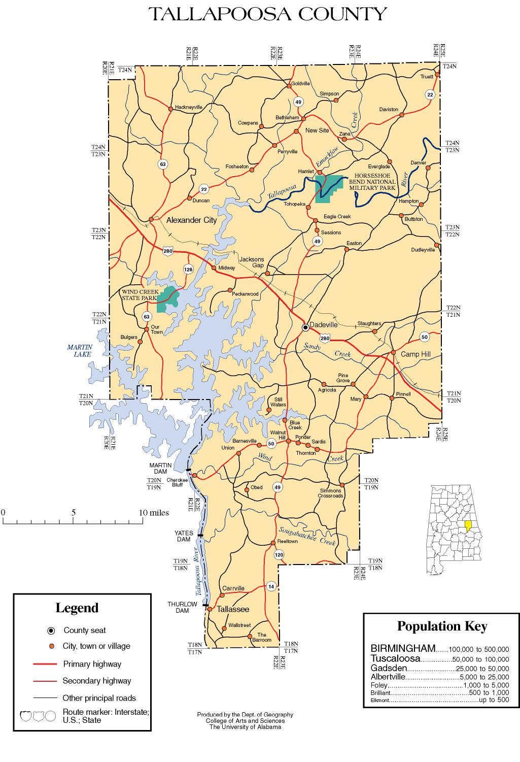
Tallapoosa County is a county located in the east-central portion of the U.S. state of Alabama.[1] As of the 2020 census, the population was 41,311.[2] Its county seat is Dadeville.[3] Its largest city is Alexander City.
Etymology
The name Tallapoosa is of Creek origin; many Creek villages were located along the banks of the lower river before Indian Removal in the 19th century. Tallapoosa County, Alabama is named after the Tallapoosa River, which may mean "pulverized rock" in the Choctaw language. Tallapoosa is of Creek origin and may mean "grandmother town" in the Muscogee language. The Tallapoosa branch of the Muscogee tribe is considered one of the oldest groups in the Southeast. The river was a major population center for the Creek Indians before the early 19th century.
History
In 1832, Tallapoosa County was created from lands ceded by the Creek Indians in the Treaty of Cusseta. The first county seat was the Creek town of Okfuskee. The forced removal of the Creeks in 1836 and 1837 was followed by a frantic gold rush, bringing a flood of profit seekers and settlers.
Established on December 18, 1832.[1] Tallapoosa County's southwest strip of the county was detached from Tallapoosa County to become a portion of Elmore County when it was established on February 15, 1866.
The Battle of Horseshoe Bend was fought in the territory that would become Tallapoosa County in 1814. This battle effectively ended the Creek War.
Geography
According to the United States Census Bureau, the county has a total area of Script error: No such module "convert"., of which Script error: No such module "convert". is land and Script error: No such module "convert". (6.5%) is water.[4] The county is located in the Piedmont region of the state.
The county is intersected by the Tallapoosa River.[5]
Major highways
- File:US 280.svg U.S. Highway 280
- File:Alabama 14.svg State Route 14
- File:Alabama 22.svg State Route 22
- File:Alabama 49.svg State Route 49
- File:Alabama 50.svg State Route 50
- File:Alabama 63.svg State Route 63
- File:Alabama 120.svg State Route 120
- File:Alabama 128.svg State Route 128
- File:Alabama 259.svg State Route 259
Adjacent counties
- Clay County (north)
- Randolph County (northeast)
- Chambers County (east)
- Lee County (southeast)
- Macon County (south)
- Elmore County (southwest)
- Coosa County (west)
National protected area
Demographics
<templatestyles src="US Census population/styles.css"/>
| Census | Pop. | Template:Sronly | %± |
|---|---|---|---|
| 1840 | 6,444 | — | |
| 1850 | 15,584 | Script error: No such module "String".% | |
| 1860 | 23,827 | Script error: No such module "String".% | |
| 1870 | 16,963 | Script error: No such module "String".% | |
| 1880 | 23,401 | Script error: No such module "String".% | |
| 1890 | 25,460 | Script error: No such module "String".% | |
| 1900 | 29,675 | Script error: No such module "String".% | |
| 1910 | 31,034 | Script error: No such module "String".% | |
| 1920 | 29,744 | Script error: No such module "String".% | |
| 1930 | 31,188 | Script error: No such module "String".% | |
| 1940 | 35,270 | Script error: No such module "String".% | |
| 1950 | 35,074 | Script error: No such module "String".% | |
| 1960 | 35,007 | Script error: No such module "String".% | |
| 1970 | 33,840 | Script error: No such module "String".% | |
| 1980 | 38,766 | Script error: No such module "String".% | |
| 1990 | 38,826 | Script error: No such module "String".% | |
| 2000 | 41,475 | Script error: No such module "String".% | |
| 2010 | 41,616 | Script error: No such module "String".% | |
| 2020 | 41,311 | Script error: No such module "String".% | |
| 2024 (est.) | 40,699 | [6] | Script error: No such module "String".% |
| U.S. Decennial Census[7] 1790–1960[8] 1900–1990[9] 1990–2000[10] 2010–2020[2] | |||
Script error: No such module "Check for unknown parameters".
Racial and ethnic composition
| Race / Ethnicity (NH = Non-Hispanic) | Pop 2000[11] | Pop 2010[12] | Pop 2020[13] | % 2000 | % 2010 | % 2020 |
|---|---|---|---|---|---|---|
| White alone (NH) | 30,342 | 28,838 | 28,252 | 73.16% | 69.30% | 68.39% |
| Black or African American alone (NH) | 10,488 | 11,050 | 10,366 | 25.29% | 26.55% | 25.09% |
| Native American or Alaska Native alone (NH) | 107 | 119 | 84 | 0.26% | 0.29% | 0.20% |
| Asian alone (NH) | 74 | 197 | 222 | 0.18% | 0.47% | 0.54% |
| Pacific Islander alone (NH) | 3 | 2 | 0 | 0.01% | 0.00% | 0.00% |
| Other race alone (NH) | 5 | 22 | 91 | 0.01% | 0.05% | 0.22% |
| Mixed race or Multiracial (NH) | 214 | 346 | 1,152 | 0.52% | 0.83% | 2.79% |
| Hispanic or Latino (any race) | 242 | 1,042 | 1,144 | 0.58% | 2.50% | 2.77% |
| Total | 41,475 | 41,616 | 41,311 | 100.00% | 100.00% | 100.00% |
2020 census
As of the 2020 census, the county had a population of 41,311. The median age was 46.4 years. 20.1% of residents were under the age of 18 and 22.5% of residents were 65 years of age or older. For every 100 females there were 94.5 males, and for every 100 females age 18 and over there were 91.3 males age 18 and over.[14][15]
The racial makeup of the county was 68.9% White, 25.2% Black or African American, 0.3% American Indian and Alaska Native, 0.5% Asian, 0.0% Native Hawaiian and Pacific Islander, 1.6% from some other race, and 3.4% from two or more races. Hispanic or Latino residents of any race comprised 2.8% of the population.[15]
21.6% of residents lived in urban areas, while 78.4% lived in rural areas.[16]
There were 17,376 households in the county, of which 26.9% had children under the age of 18 living with them and 31.1% had a female householder with no spouse or partner present. About 29.4% of all households were made up of individuals and 14.3% had someone living alone who was 65 years of age or older.[14]
There were 22,686 housing units, of which 23.4% were vacant. Among occupied housing units, 71.3% were owner-occupied and 28.7% were renter-occupied. The homeowner vacancy rate was 1.7% and the rental vacancy rate was 9.0%.[14]
2010 census
As of the census of 2010, there were 41,616 people, 16,985 households, and 11,762 families living in the county. The population density was Script error: No such module "convert".. There were 22,111 housing units at an average density of Script error: No such module "convert".. The racial makeup of the county was 69.9% White, 26.6% Black or African American, 0.3% Native American, 0.5% Asian, 0% Pacific Islander, 1.7% from other races, and 1.0% from two or more races. Nearly 2.5% of the population were Hispanic or Latino of any race.[17] There were 16,985 households, 25.6% had children under the age of 18 living with them, 48.4% were married couples living together, 15.9% had a female householder with no husband present, and 30.8% were non-families. Nearly 27.2% of households were made up of individuals, and 11.4% were one person aged 65 or older. The average household size was 2.42, and the average family size was 2.91.
The age distribution was 22.2% under the age of 18, 8.0% from 18 to 24, 23.3% from 25 to 44, 29.2% from 45 to 64, and 17.3% 65 or older. The median age was 42.4 years. For every 100 females, there were 94.2 males. For every 100 females age 18 and over, there were 95.8 males.
The median household income was $36,904 and the median family income was $47,918. Males had a median income of $34,625 versus $28,616 for females. The per capita income for the county was $22,542. About 13.4% of families and 17.5% of the population were below the poverty line, including 27.8% of those under age 18 and 9.1% of those age 65 or over.
2000 census
As of the census of 2000. there were 41,475 people, 16,656 households, and 11,809 families living in the county. The population density was Script error: No such module "convert".. There were 20,510 housing units at an average density of Script error: No such module "convert".. The racial makeup of the county was 73.48% White, 25.36% Black or African American, 0.26% Native American, 0.18% Asian, 0.01% Pacific Islander, 0.17% from other races, and 0.54% from two or more races. Nearly 0.58% of the population were Hispanic or Latino of any race.[18] There were 16,656 households, 29.90% had children under the age of 18 living with them, 53.00% were married couples living together, 14.30% had a female householder with no husband present, and 29.10% were non-families. Nearly 26.50% of households were made up of individuals, and 11.60% were one person aged 65 or older. The average household size was 2.44, and the average family size was 2.94.
The age distribution was 24.20% under the age of 18, 7.60% from 18 to 24, 26.70% from 25 to 44, 24.90% from 45 to 64, and 16.60% 65 or older. The median age was 39 years. For every 100 females, there were 90.50 males. For every 100 females age 18 and over, there were 86.10 males.
The median household income was $30,745 and the median family income was $38,148. Males had a median income of $28,557 versus $19,885 for females. The per capita income for the county was $16,909. About 13.50% of families and 16.60% of the population were below the poverty line, including 24.30% of those under age 18 and 15.60% of those age 65 or over.
Politics
Tallapoosa County is a Republican county. The last Democrat to win the county was Jimmy Carter in 1980. Template:PresHead Template:PresRow Template:PresRow Template:PresRow Template:PresRow Template:PresRow Template:PresRow Template:PresRow Template:PresRow Template:PresRow Template:PresRow Template:PresRow Template:PresRow Template:PresRow Template:PresRow Template:PresRow Template:PresRow Template:PresRow Template:PresRow Template:PresRow Template:PresRow Template:PresRow Template:PresRow Template:PresRow Template:PresRow Template:PresRow Template:PresRow Template:PresRow Template:PresRow Template:PresRow Template:PresRow Template:PresRow Template:PresFoot
Communities
Cities
- Alexander City
- Dadeville (county seat)
- Tallassee (partly in Elmore County)
Towns
Census-designated places
Unincorporated communities
Education
School districts in the county include:[19]
- Alexander City City School District
- Tallapoosa County School District
- Tallassee City School District
See also
- National Register of Historic Places listings in Tallapoosa County, Alabama
- Properties on the Alabama Register of Landmarks and Heritage in Tallapoosa County, Alabama
References
<templatestyles src="Reflist/styles.css" />
- ↑ a b "ACES Tallapoosa County Office" (links/history), Alabama Cooperative Extension System (ACES), 2007, webpage: ACES-Tallapoosa.
- ↑ a b Script error: No such module "citation/CS1".
- ↑ Script error: No such module "citation/CS1".
- ↑ Script error: No such module "citation/CS1".
- ↑ Template:Cite AmCyc
- ↑ Script error: No such module "citation/CS1".
- ↑ Script error: No such module "citation/CS1".
- ↑ Script error: No such module "citation/CS1".
- ↑ Script error: No such module "citation/CS1".
- ↑ Script error: No such module "citation/CS1".
- ↑ Script error: No such module "citation/CS1".
- ↑ Script error: No such module "citation/CS1".
- ↑ Script error: No such module "citation/CS1".
- ↑ a b c Script error: No such module "citation/CS1".
- ↑ a b Script error: No such module "citation/CS1".
- ↑ Script error: No such module "citation/CS1".
- ↑ Script error: No such module "citation/CS1".
- ↑ Script error: No such module "citation/CS1".
- ↑ Script error: No such module "citation/CS1". - Text list
Script error: No such module "Check for unknown parameters".
External links
- Tallapoosa County map of roads/towns (map © 2007 Univ. of Alabama).
- USGenWeb http://www.usgwarchives.net/al/tallapoosa.htm
Template:Geographic Location Script error: No such module "Navbox". Script error: No such module "navbox".
Script error: No such module "Coordinates".