Jarisha
Template:Pp-extended Script error: No such module "Settlement short description".Script error: No such module "Infobox".Script error: No such module "Check for unknown parameters".Script error: No such module "Check for conflicting parameters".Expression error: Unexpected < operator Jarisha (Template:Langx, also transliterated Jerisha; Template:Langx) was a Palestinian Arab village located Script error: No such module "convert". from the ancient site of Tell Jarisha (Tel Gerisa), on the south bank of Al-Awja (Yarkon River).[1][2] After the establishment of Tel Aviv, it was one of five Arab villages to fall within its municipal boundaries.[3] Jarisha was depopulated in the lead up to the 1948 Arab-Israeli war.[2]
History
Early Bronze Age
Jarisha was located only Script error: No such module "convert". from Tel Gerisa, an archaeological site dating to the Early Bronze II period (2800-2600 BC).
Middle Bronze Age
In the Middle Bronze period (2000-1500 BC) the site was a fortified Hyksos town.
Late Bronze Age and Iron Age
It was succeeded by a Philistine settlement around the 12th century BC.[4]
Ottoman period
In the 1596 tax records under the Ottoman Empire, it was a village in the nahiya ("subdistrict") of the Bani Sa'b, part of Nablus Sanjak. It had a population of 22 Muslim households; an estimated 121 persons, who paid taxes on buffalo, goats and beehives; a total of 2,150 akçe.[5]
In 1856 the village was named Darishah on Kiepert's map of Palestine published that year.[6] An Ottoman village list from about 1870 showed that the village had a population of 76 in a total of 38 houses, though that population count included men, only. It was further noted that it was located 6000 meters NE of Jaffa.[7][8]
In 1882 the PEF's Survey of Western Palestine (SWP) described the village, transcribed as "Jerisheh", as being built of adobe bricks and flanked by an olive grove. It had a well and a mill.[9] South-east of the village was the ruins of a Khan, a graveyard and some caves, also a masonry dam and a small bridge, "apparently Saracenic".[10]
British Mandate era
In the 1922 census of Palestine conducted by the British Mandate authorities, Jerisheh had a population of 57, all Muslims[11] increasing by the 1931 census to 183, still all Muslims, in a total of 43 houses.[12]
Since May 1944, Jarisha was part of the municipality of Ramat Gan.[13]
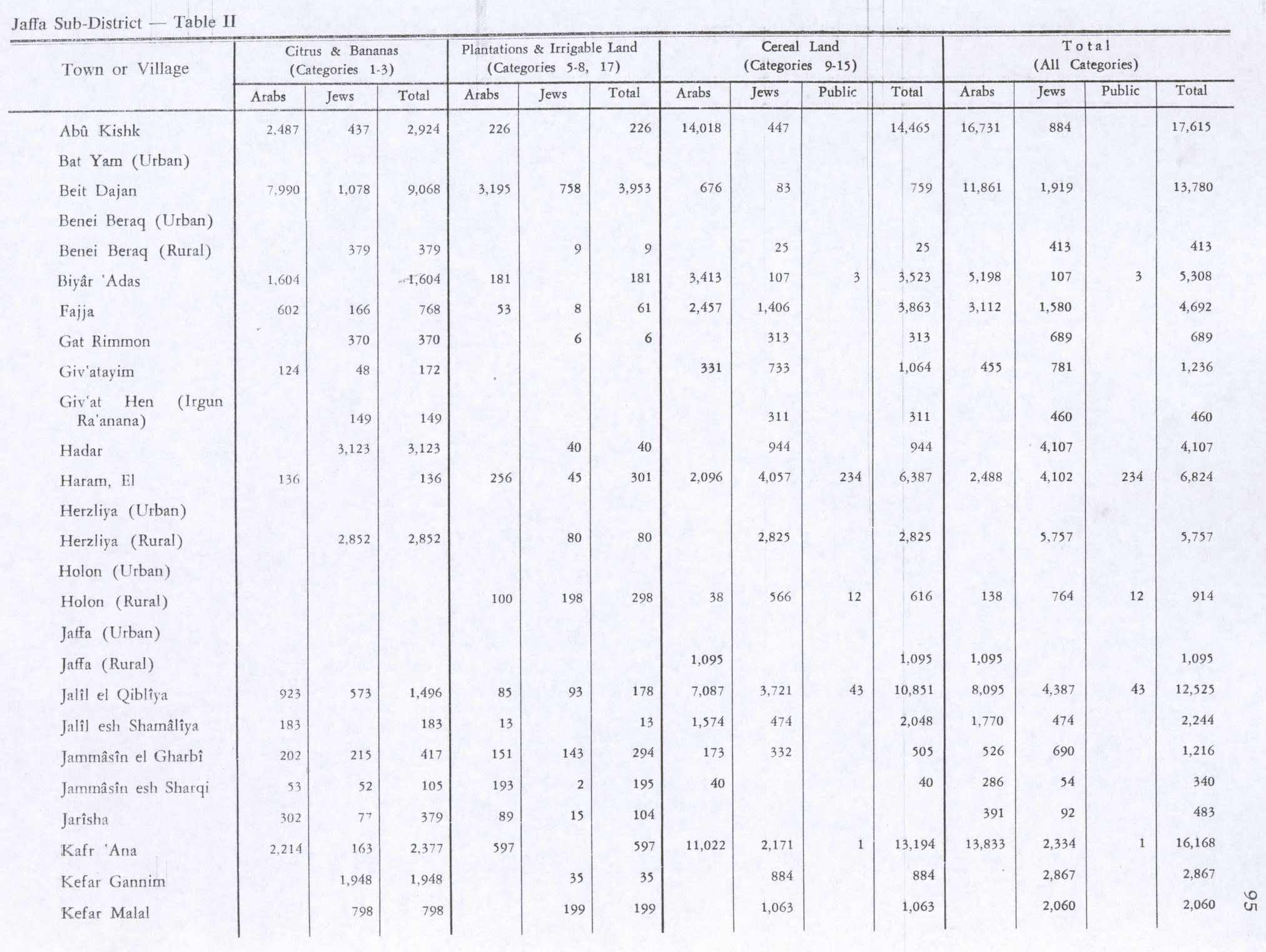
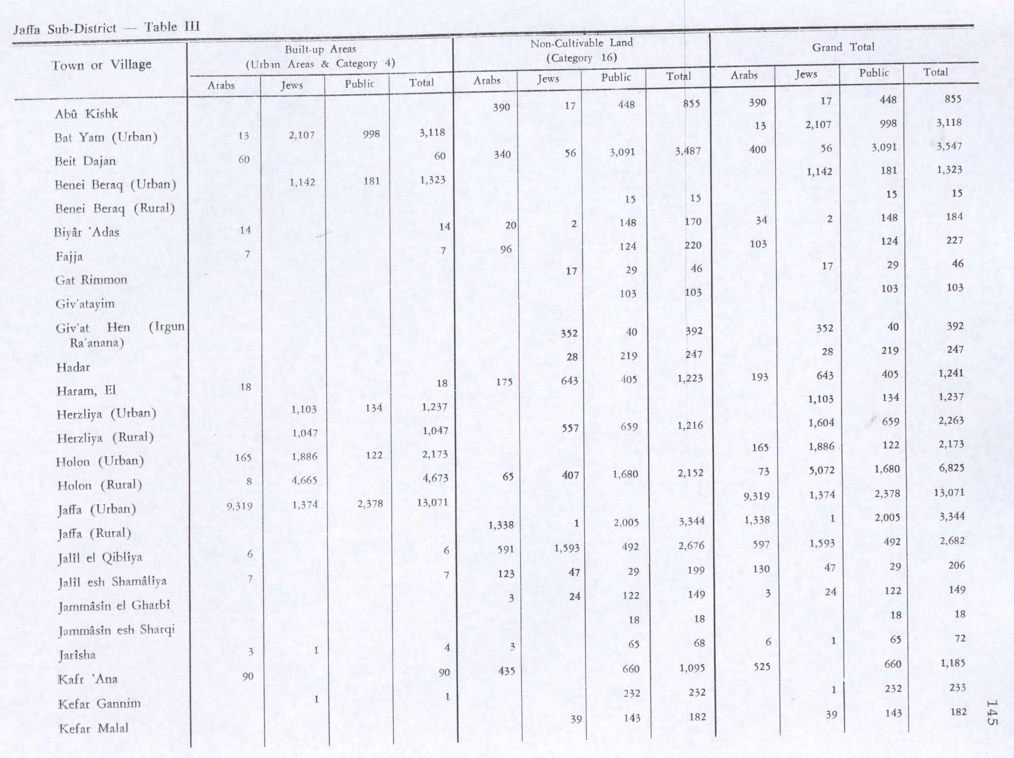
In the 1945 statistics it had a population of 190 Muslims,[14] with 555 dunams of land.[15] The villagers worked in the service industry, but some also grew fruits and vegetables; in 1944-45 a total of 302 dunums of village land was used for citrus and bananas, and 89 dunums were irrigated or used for orchards.[16] 3 dunams were classified as built-up areas.[17]
1948, and after
According to the Palestinian historian Walid Khalidi, the state of the village site in 1992 was as follows: "The site has been completely covered over by highways and suburban houses."[18]
Gallery
-
Seven Mills sign in Yarkon Park: “Nothing remains of the impoverished Jarisha village which was situated here in the past”
-
Jarisha village in the Map of Jaffa Tel Aviv Compiled, drawn and printed by the Survey of Palestine 1944
-
Jarisha (Jrishe) 1928 1:20,000
-
Jarisha 1945 1:250,000


See also
References
<templatestyles src="Reflist/styles.css" />
- ↑ Ben-Tor and Greenberg, 1992, p. 246.
- ↑ a b Khalidi and Elmusa, 1992, p. 246.
- ↑ Mann, 2006, p. 246.
- ↑ Khalidi, 1992, p. 246
- ↑ Hütteroth and Abdulfattah, 1977, p. 139; cited in Khalidi, 1992, p. 246
- ↑ Kiepert, 1856, Map of Southern Palestine
- ↑ Deschelscheh, in Socin, 1879, p. 152
- ↑ Hartmann, 1883, p. 137, also noted 38 houses at el−dscherische
- ↑ Conder and Kitchener, 1882, SWP II, p. 251. Quoted in Khalidi, 1992, p.246
- ↑ Conder and Kitchener, 1882, SWP II, p. 265
- ↑ Barron, 1923, Table VII, Sub-district of Jaffa, p. 20
- ↑ Mills, 1932, p. 14
- ↑ Script error: No such module "citation/CS1".
- ↑ Cite error: Script error: No such module "Namespace detect".Script error: No such module "Namespace detect".
- ↑ Cite error: Script error: No such module "Namespace detect".Script error: No such module "Namespace detect".
- ↑ Government of Palestine, Department of Statistics. Village Statistics, April, 1945. Quoted in Hadawi, 1970, p. 95 Also in Khalidi, 1992, p.246-247
- ↑ Government of Palestine, Department of Statistics. Village Statistics, April, 1945. Quoted in Hadawi, 1970, p. 145
- ↑ Khalidi, 1992, p. 247

Script error: No such module "Check for unknown parameters".
Bibliography
<templatestyles src="Refbegin/styles.css" />
- Script error: No such module "citation/CS1".
- Script error: No such module "citation/CS1".
- Script error: No such module "citation/CS1". (pp. 192−196: "Les Trois−Ponts, Jorgilia")
- Script error: No such module "citation/CS1".
- Script error: No such module "citation/CS1".
- Script error: No such module "citation/CS1".
- Script error: No such module "Citation/CS1".
- Script error: No such module "citation/CS1".
- Script error: No such module "citation/CS1".
- Script error: No such module "citation/CS1".
- Script error: No such module "citation/CS1".
- Script error: No such module "citation/CS1".
- Script error: No such module "citation/CS1".
- Script error: No such module "Citation/CS1".
External links
- Welcome to Jarisha
- Jarisha, Zochrot
- Jarisha from the Khalil Sakakini Cultural Center
- Survey of Western Palestine, Map 13: IAA, Wikimedia commons

Template:Palestinian Arab villages depopulated during the 1948 Palestine War