Perry County, Alabama: Difference between revisions
imported>GreenC bot Move 1 url. Wayback Medic 2.5 per WP:URLREQ#usda.gov |
imported>WikiOriginal-9 m caps |
||
| Line 15: | Line 15: | ||
| population_as_of = 2020 | | population_as_of = 2020 | ||
| population_total = 8511 | | population_total = 8511 | ||
| pop_est_as_of = | | pop_est_as_of = 2024 | ||
| population_est = | | population_est = 7719 {{decrease}} | ||
| population_density_sq_mi = auto | | population_density_sq_mi = auto | ||
| time zone = Central | | time zone = Central | ||
| web = https://www.perrycountyal.gov/home | | web = https://www.perrycountyal.gov/home | ||
| ex image = Perry County Alabama Courthouse.jpg | | ex image = Perry County Alabama Courthouse.jpg | ||
| ex image cap = Perry County | | ex image cap = Perry County Courthouse in Marion | ||
| district = 7th | | district = 7th | ||
| named for = [[Oliver Hazard Perry]] | | named for = [[Oliver Hazard Perry]] | ||
| Line 81: | Line 81: | ||
|2010= 10591 | |2010= 10591 | ||
|2020= 8511 | |2020= 8511 | ||
|estyear= | |estyear=2024 | ||
|estimate= | |estimate=7719 | ||
|estref=<ref name=" | |estref=<ref name="USCensusEst2024">{{cite web|url=https://www.census.gov/data/tables/time-series/demo/popest/2020s-counties-total.html|title=County Population Totals and Components of Change: 2020-2024|publisher=United States Census Bureau|access-date=September 4, 2025}}</ref> | ||
|align-fn=center | |align-fn=center | ||
|footnote=U.S. Decennial Census<ref>{{cite web|url=https://www.census.gov/programs-surveys/decennial-census.html|title=U.S. Decennial Census|publisher=United States Census Bureau|access-date=August 22, 2015}}</ref><br />1790–1960<ref>{{cite web|url=http://mapserver.lib.virginia.edu|title=Historical Census Browser|publisher=University of Virginia Library|access-date=August 22, 2015}}</ref> 1900–1990<ref>{{cite web|url=https://www.census.gov/population/cencounts/al190090.txt|title=Population of Counties by Decennial Census: 1900 to 1990|publisher=United States Census Bureau|editor-last=Forstall|editor-first=Richard L.|date=March 24, 1995|access-date=August 22, 2015}}</ref><br />1990–2000<ref>{{cite web|url=https://www.census.gov/population/www/cen2000/briefs/phc-t4/tables/tab02.pdf|title=Census 2000 PHC-T-4. Ranking Tables for Counties: 1990 and 2000|publisher=United States Census Bureau|date=April 2, 2001|access-date=August 22, 2015}}</ref> 2010–2020<ref name="QF"/> | |footnote=U.S. Decennial Census<ref>{{cite web|url=https://www.census.gov/programs-surveys/decennial-census.html|title=U.S. Decennial Census|publisher=United States Census Bureau|access-date=August 22, 2015}}</ref><br />1790–1960<ref>{{cite web|url=http://mapserver.lib.virginia.edu|title=Historical Census Browser|publisher=University of Virginia Library|access-date=August 22, 2015}}</ref> 1900–1990<ref>{{cite web|url=https://www.census.gov/population/cencounts/al190090.txt|title=Population of Counties by Decennial Census: 1900 to 1990|publisher=United States Census Bureau|editor-last=Forstall|editor-first=Richard L.|date=March 24, 1995|access-date=August 22, 2015}}</ref><br />1990–2000<ref>{{cite web|url=https://www.census.gov/population/www/cen2000/briefs/phc-t4/tables/tab02.pdf|title=Census 2000 PHC-T-4. Ranking Tables for Counties: 1990 and 2000|publisher=United States Census Bureau|date=April 2, 2001|access-date=August 22, 2015}}</ref> 2010–2020<ref name="QF"/> | ||
| Line 177: | Line 177: | ||
===2010 census=== | ===2010 census=== | ||
As of the [[2010 United States | As of the [[2010 United States census]], there were 10,591 people living in the county. 68.7% were [[African American|Black or African American]], 30.3% [[White American|White]], 0.3% [[Asian American|Asian]], 0.2% [[Native Americans in the United States|Native American]], 0.2% of some other race and 0.4% [[Multiracial American|of two or more races]]. 1.1% were [[Hispanic and Latino Americans|Hispanic or Latino]] (of any race). | ||
===2000 census=== | ===2000 census=== | ||
| Line 192: | Line 192: | ||
{{PresHead|place=Perry County, Alabama|source=<ref name="DL">{{cite web|title=Dave Leip's Atlas of U.S. Presidential Elections|url=http://uselectionatlas.org/RESULTS/|access-date=November 21, 2016}}</ref>}} | {{PresHead|place=Perry County, Alabama|source=<ref name="DL">{{cite web|title=Dave Leip's Atlas of U.S. Presidential Elections|url=http://uselectionatlas.org/RESULTS/|access-date=November 21, 2016}}</ref>}} | ||
<!-- PresRow should be {{PresRow|Year|Winning party|GOP vote #|Dem vote #|3rd party vote #|State}} --> | <!-- PresRow should be {{PresRow|Year|Winning party|GOP vote #|Dem vote #|3rd party vote #|State}} --> | ||
{{PresRow|1824|Democratic|58|252|60|Alabama}} | |||
{{PresRow|1828|Democratic|58|636|0|Alabama}} | |||
{{PresRow|1832|Democratic|0|504|0|Alabama}} | |||
{{PresRow|1836|Whig|827|290|0|Alabama}} | |||
{{PresRow|1840|Whig|973|825|0|Alabama}} | |||
{{PresRow|1844|Whig|869|849|0|Alabama}} | |||
{{PresRow|1848|Whig|826|631|0|Alabama}} | |||
{{PresRow|1852|Democratic|261|512|13|Alabama}} | |||
{{PresRow|1856|Know Nothing|0|808|824|Alabama}} | |||
{{PresRow|1860|Southern Democratic|0|99|1,773|Alabama}} | |||
{{PresRow|1868|Republican|3,733|1,337|0|Alabama}} | |||
{{PresRow|1872|Republican|4,143|1,384|0|Alabama}} | |||
{{PresRow|1876|Republican|3,528|1,467|0|Alabama}} | |||
{{PresRow|1880|Democratic|2,082|2,278|0|Alabama}} | |||
{{PresRow|1884|Democratic|1,079|3,508|15|Alabama}} | |||
{{PresRow|1888|Democratic|790|2,729|0|Alabama}} | |||
{{PresRow|1892|Democratic|48|3,452|748|Alabama}} | |||
{{PresRow|1896|Democratic|463|2,682|44|Alabama}} | |||
{{PresRow|1900|Democratic|80|1,748|28|Alabama}} | |||
{{PresRow|1904|Democratic|47|799|94|Alabama}} | |||
{{PresRow|1908|Democratic|12|776|4|Alabama}} | |||
{{PresRow|1912|Democratic|3|731|45|Alabama}} | |||
{{PresRow|1916|Democratic|20|895|13|Alabama}} | |||
{{PresRow|1920|Democratic|34|1,195|14|Alabama}} | |||
{{PresRow|1924|Democratic|25|928|12|Alabama}} | |||
{{PresRow|1928|Democratic|459|1,242|1|Alabama}} | |||
{{PresRow|1932|Democratic|37|1,382|35|Alabama}} | |||
{{PresRow|1936|Democratic|24|1,527|0|Alabama}} | |||
{{PresRow|1940|Democratic|39|1,509|5|Alabama}} | |||
{{PresRow|1944|Democratic|47|1,004|2|Alabama}} | |||
{{PresRow|1948|Dixiecrat|30|0|1,051|Alabama}} | |||
{{PresRow|1952|Democratic|756|1,352|4|Alabama}} | |||
{{PresRow|1956|Democratic|613|974|225|Alabama}} | |||
{{PresRow|1960|Democratic|744|973|75|Alabama}} | |||
{{PresRow|1964|Republican|2,046|0|520|Alabama}} | |||
{{PresRow|1968|American Independent|308|2,457|2,788|Alabama}} | |||
{{PresRow|1972|Republican|2,800|2,718|181|Alabama}} | |||
{{PresRow|1976|Democratic|2,164|4,486|33|Alabama}} | |||
{{PresRow|1980|Democratic|2,262|4,208|52|Alabama}} | |||
{{PresRow|1984|Democratic|2,600|2,731|77|Alabama}} | |||
{{PresRow|1988|Democratic|2,107|3,574|77|Alabama}} | |||
{{PresRow|1992|Democratic|1,829|3,712|272|Alabama}} | |||
{{PresRow|1996|Democratic|1,703|4,053|147|Alabama}} | |||
{{PresRow|2000|Democratic|1,732|4,020|35|Alabama}} | |||
{{PresRow|2004|Democratic|1,738|3,767|18|Alabama}} | |||
{{PresRow|2008|Democratic|1,679|4,457|23|Alabama}} | |||
{{PresRow|2012|Democratic|1,506|4,568|27|Alabama}} | |||
{{PresRow|2016|Democratic|1,407|3,824|47|Alabama}} | |||
{{PresRow|2020|Democratic|1,339|3,860|31|Alabama}} | |||
{{PresRow|2024|Democratic|1,269|3,174|22|Alabama}} | {{PresRow|2024|Democratic|1,269|3,174|22|Alabama}} | ||
{{PresFoot}} | |||
{{PresFoot | |||
==Communities== | ==Communities== | ||
Revision as of 16:49, 16 October 2025
Template:Short description Template:Use mdy datesTemplate:Use American English Script error: No such module "Settlement short description".Script error: No such module "Infobox".Template:Template otherScript error: No such module "Check for unknown parameters".Script error: No such module "Check for conflicting parameters".Expression error: Unexpected < operator.Template:Category handlerExpression error: Unrecognized punctuation character "[".Script error: No such module "Check for unknown parameters".
Perry County is a county located in the Black Belt region in the central part of the U.S. state of Alabama. As of the 2020 census, the population was 8,511.[1] Its county seat is Marion.[2] The county was established in 1819 and is named in honor of Commodore Oliver Hazard Perry of Rhode Island and the United States Navy.[3] since 2020,[update]Template:Dated maintenance category (articles)Script error: No such module "Check for unknown parameters". Perry County was the only county in Alabama, and one of 40 in the United States, not to have access to any wired broadband connections.[4]
History
In 1935, a sharecropper called Joe Spinner Johnson was organizing sharecroppers into a union. His landlord called him away from his job, and gave him up to a gang of whites. They tied him up, beat him, and took him to Selma, where he was thrown in jail. Other prisoners heard him screaming and being beaten. A few days later, his mutilated body turned up near Greensboro.[5]
The Perry County town of Marion was the site of a 1965 killing of an unarmed Black man, Jimmie Lee Jackson, by a white state trooper, James Bonard Fowler, which sparked the Selma to Montgomery marches. In 2008, the county voted to establish a Barack Obama Day, a legal holiday, every second Monday of November.[6]
Geography
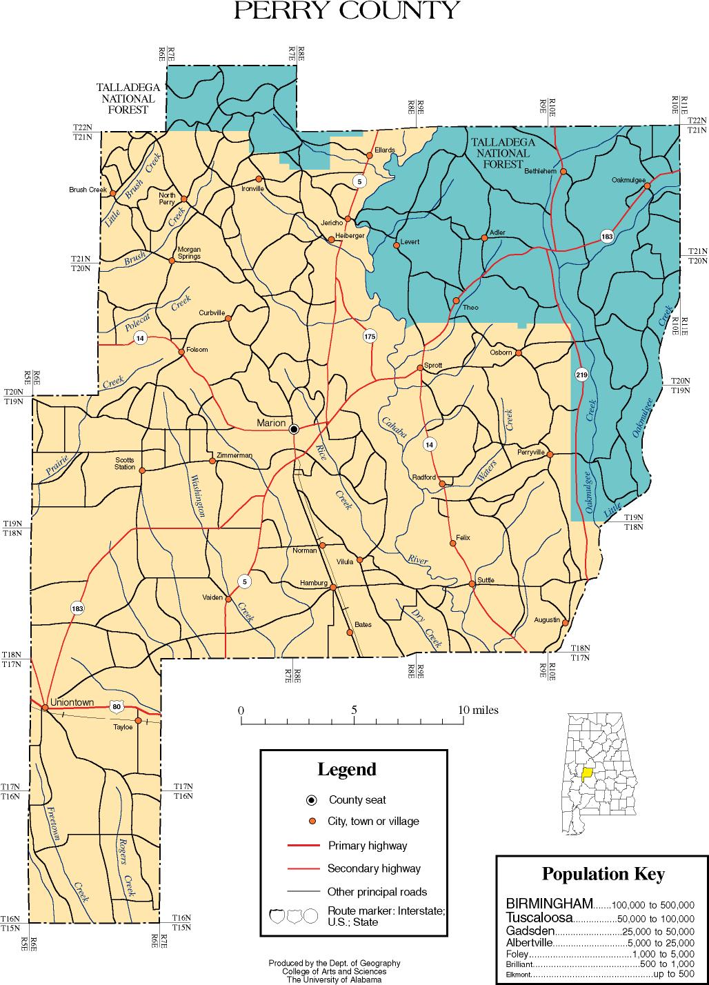
According to the United States Census Bureau, the county has a total area of Script error: No such module "convert"., of which Script error: No such module "convert". is land and Script error: No such module "convert". (0.6%) is water.[7] The county boasts a diverse geography, with the southern half of the county being located in the Gulf Coastal Plain region, and the northern half of the county being located in the far southern extensions of the foothills of the Ridge-and-Valley Appalachians. This area is mainly forested, with some hills and valleys.[8]
Major highways
- File:US 80.svg U.S. Highway 80
- File:Alabama 5.svg State Route 5
- File:Alabama 14.svg State Route 14
- File:Alabama 61.svg State Route 61
- File:Alabama 175.svg State Route 175
- File:Alabama 183.svg State Route 183
- File:Alabama 219.svg State Route 219
- File:Alabama 289.svg State Route 289
Adjacent counties
- Bibb County (north)
- Chilton County (northeast)
- Dallas County (east)
- Marengo County (southwest)
- Hale County (west)
National protected area
- Talladega National Forest (part)
Demographics
<templatestyles src="US Census population/styles.css"/>
| Census | Pop. | Template:Sronly | %± |
|---|---|---|---|
| 1820 | 3,646 | — | |
| 1830 | 11,490 | Script error: No such module "String".% | |
| 1840 | 19,086 | Script error: No such module "String".% | |
| 1850 | 22,285 | Script error: No such module "String".% | |
| 1860 | 27,724 | Script error: No such module "String".% | |
| 1870 | 24,975 | Script error: No such module "String".% | |
| 1880 | 30,741 | Script error: No such module "String".% | |
| 1890 | 29,332 | Script error: No such module "String".% | |
| 1900 | 31,783 | Script error: No such module "String".% | |
| 1910 | 31,222 | Script error: No such module "String".% | |
| 1920 | 25,373 | Script error: No such module "String".% | |
| 1930 | 26,385 | Script error: No such module "String".% | |
| 1940 | 26,610 | Script error: No such module "String".% | |
| 1950 | 20,439 | Script error: No such module "String".% | |
| 1960 | 17,358 | Script error: No such module "String".% | |
| 1970 | 15,388 | Script error: No such module "String".% | |
| 1980 | 15,012 | Script error: No such module "String".% | |
| 1990 | 12,759 | Script error: No such module "String".% | |
| 2000 | 11,861 | Script error: No such module "String".% | |
| 2010 | 10,591 | Script error: No such module "String".% | |
| 2020 | 8,511 | Script error: No such module "String".% | |
| 2024 (est.) | 7,719 | [9] | Script error: No such module "String".% |
| U.S. Decennial Census[10] 1790–1960[11] 1900–1990[12] 1990–2000[13] 2010–2020[1] | |||
Script error: No such module "Check for unknown parameters".
2020 Census
| Race / Ethnicity (NH = Non-Hispanic) | Pop 2000[14] | Pop 2010[15] | Pop 2020[16] | % 2000 | % 2010 | % 2020 |
|---|---|---|---|---|---|---|
| White alone (NH) | 3,642 | 3,142 | 2,345 | 30.71% | 29.67% | 27.55% |
| Black or African American alone (NH) | 8,057 | 7,244 | 5,914 | 67.93% | 68.40% | 69.49% |
| Native American or Alaska Native alone (NH) | 9 | 17 | 15 | 0.08% | 0.16% | 0.18% |
| Asian alone (NH) | 4 | 30 | 10 | 0.03% | 0.28% | 0.12% |
| Pacific Islander alone (NH) | 2 | 5 | 1 | 0.02% | 0.05% | 0.01% |
| Other race alone (NH) | 1 | 4 | 0 | 0.01% | 0.04% | 0.00% |
| Mixed race or Multiracial (NH) | 44 | 35 | 137 | 0.37% | 0.33% | 1.61% |
| Hispanic or Latino (any race) | 102 | 114 | 89 | 0.86% | 1.08% | 1.05% |
| Total | 11,861 | 10,591 | 8,511 | 100.00% | 100.00% | 100.00% |
As of the 2020 United States census, there were 8,511 people, 3,070 households, and 1,476 families residing in the county.
Perry County was ranked as the county with the level of obesity by U.S. News & World Report, with a 52.5% obesity rate in 2024.[17]
2010 census
As of the 2010 United States census, there were 10,591 people living in the county. 68.7% were Black or African American, 30.3% White, 0.3% Asian, 0.2% Native American, 0.2% of some other race and 0.4% of two or more races. 1.1% were Hispanic or Latino (of any race).
2000 census
As of the census[18] of 2000, there were 11,861 people, 4,333 households, and 3,046 families living in the county. The population density was Script error: No such module "convert".. There were 5,406 housing units at an average density of Script error: No such module "convert".. The racial makeup of the county was 68.38% Black or African American, 30.86% White, 0.08% Native American, 0.03% Asian, 0.03% Pacific Islander, 0.08% from other races, and 0.54% from two or more races. Nearly 0.86% of the population were Hispanic or Latino of any race.
There were 4,333 households, out of which 33.80% had children under the age of 18 living with them, 40.40% were married couples living together, 25.10% had a female householder with no husband present, and 29.70% were non-families. Nearly 27.90% of all households were made up of individuals, and 12.00% had someone living alone who was 65 years of age or older. The average household size was 2.63, and the average family size was 3.23.
In the county, the population was spread out, with 29.80% under the age of 18, 11.10% from 18 to 24, 23.60% from 25 to 44, 20.70% from 45 to 64, and 14.90% who were 65 years of age or older. The median age was 33 years. For every 100 females, there were 83.90 males. For every 100 females age 18 and over, there were 78.40 males.
The median income for a household in the county was $20,200, and the median income for a family was $26,150. Males had a median income of $26,272 versus $16,839 for females. The per capita income for the county was $10,948. About 31.20% of families and 35.40% of the population were below the poverty line, including 48.90% of those under age 18 and 25.80% of those age 65 or over.
Politics
Perry County is a heavily Democratic county like most of the Black Belt in Alabama. The last Republican to win the county was Richard Nixon in 1972 who won the county by only 82 votes. Template:PresHead Template:PresRow Template:PresRow Template:PresRow Template:PresRow Template:PresRow Template:PresRow Template:PresRow Template:PresRow Template:PresRow Template:PresRow Template:PresRow Template:PresRow Template:PresRow Template:PresRow Template:PresRow Template:PresRow Template:PresRow Template:PresRow Template:PresRow Template:PresRow Template:PresRow Template:PresRow Template:PresRow Template:PresRow Template:PresRow Template:PresRow Template:PresRow Template:PresRow Template:PresRow Template:PresRow Template:PresRow Template:PresRow Template:PresRow Template:PresRow Template:PresRow Template:PresRow Template:PresRow Template:PresRow Template:PresRow Template:PresRow Template:PresRow Template:PresRow Template:PresRow Template:PresRow Template:PresRow Template:PresRow Template:PresRow Template:PresRow Template:PresRow Template:PresRow Template:PresFoot
Communities
Cities
Unincorporated communities
<templatestyles src="Div col/styles.css"/>
Places of interest
Perry County is home to Perry Lakes Park, part of the Talladega National Forest, the Alabama Women's Hall of Fame located at Judson College, and Marion Military Institute.
See also
- National Register of Historic Places listings in Perry County, Alabama
- Properties on the Alabama Register of Landmarks and Heritage in Perry County, Alabama
References
<templatestyles src="Reflist/styles.css" />
- ↑ a b Script error: No such module "citation/CS1".
- ↑ Script error: No such module "citation/CS1".
- ↑ Script error: No such module "citation/CS1".
- ↑ Script error: No such module "citation/CS1".
- ↑ Script error: No such module "citation/CS1".
- ↑ Script error: No such module "citation/CS1".
- ↑ Script error: No such module "citation/CS1".
- ↑ Script error: No such module "citation/CS1".
- ↑ Script error: No such module "citation/CS1".
- ↑ Script error: No such module "citation/CS1".
- ↑ Script error: No such module "citation/CS1".
- ↑ Script error: No such module "citation/CS1".
- ↑ Script error: No such module "citation/CS1".
- ↑ Script error: No such module "citation/CS1".
- ↑ Script error: No such module "citation/CS1".
- ↑ Script error: No such module "citation/CS1".
- ↑ Script error: No such module "citation/CS1".
- ↑ Script error: No such module "citation/CS1".
Script error: No such module "Check for unknown parameters".
Further reading
- English, Bertis D. Civil Wars, Civil Beings, and Civil Rights in Alabama's Black Belt: A History of Perry County (University Alabama Press, 2020).
- Fraser, Rory F., Buddhi R. Gyawali, and John Schelhas. "Blacks in space: Land tenure and well-being in Perry County, Alabama." Small-Scale Forest Economics, Management and Policy 4 (2005): 21–33. online
External links
- Official website of Perry County Sheriff
- Perry County map of roads/towns (map © 2007 Univ. of Alabama)
Template:Geographic Location Script error: No such module "Navbox". Script error: No such module "navbox".
Script error: No such module "Coordinates".