Unity Township, Pennsylvania: Difference between revisions
imported>UrielAcosta |
imported>Electricmemory m Fixing typo(s), replaced: 2000 United States Census → 2000 United States census, 2020 United States Census → 2020 United States census |
||
| Line 1: | Line 1: | ||
{{short description|Township in Pennsylvania, US}} | |||
{{Use mdy dates|date=May 2024}} | {{Use mdy dates|date=May 2024}} | ||
{{Use American English|date=July 2025}} | |||
{{Infobox settlement | {{Infobox settlement | ||
| official_name = Unity Township, Pennsylvania | | official_name = Unity Township, Pennsylvania | ||
| Line 44: | Line 46: | ||
| area_land_sq_mi = 67.44 | | area_land_sq_mi = 67.44 | ||
| area_water_sq_mi = 0.14 | | area_water_sq_mi = 0.14 | ||
| population_as_of = [[2020 United States census | | population_as_of = [[2020 United States census]] | ||
| population_footnotes = <ref name="USCensusEst2020-2021">{{cite web |title=City and Town Population Totals: 2020—2021 |url=https://www.census.gov/data/tables/time-series/demo/popest/2020s-total-cities-and-towns.html |website=Census.gov |publisher=US Census Bureau |access-date=July 26, 2022}}</ref> | | population_footnotes = <ref name="USCensusEst2020-2021">{{cite web |title=City and Town Population Totals: 2020—2021 |url=https://www.census.gov/data/tables/time-series/demo/popest/2020s-total-cities-and-towns.html |website=Census.gov |publisher=US Census Bureau |access-date=July 26, 2022}}</ref> | ||
| population_total = 21724 | | population_total = 21724 | ||
| Line 85: | Line 87: | ||
According to the [[United States Census Bureau]], the township has a total area of 67.3 square miles (174.2 km{{sup|2}}), of which 67.1 square miles (173.8 km{{sup|2}}) is land and 0.2 square mile (0.4 km{{sup|2}}) (0.24%) is water. | According to the [[United States Census Bureau]], the township has a total area of 67.3 square miles (174.2 km{{sup|2}}), of which 67.1 square miles (173.8 km{{sup|2}}) is land and 0.2 square mile (0.4 km{{sup|2}}) (0.24%) is water. | ||
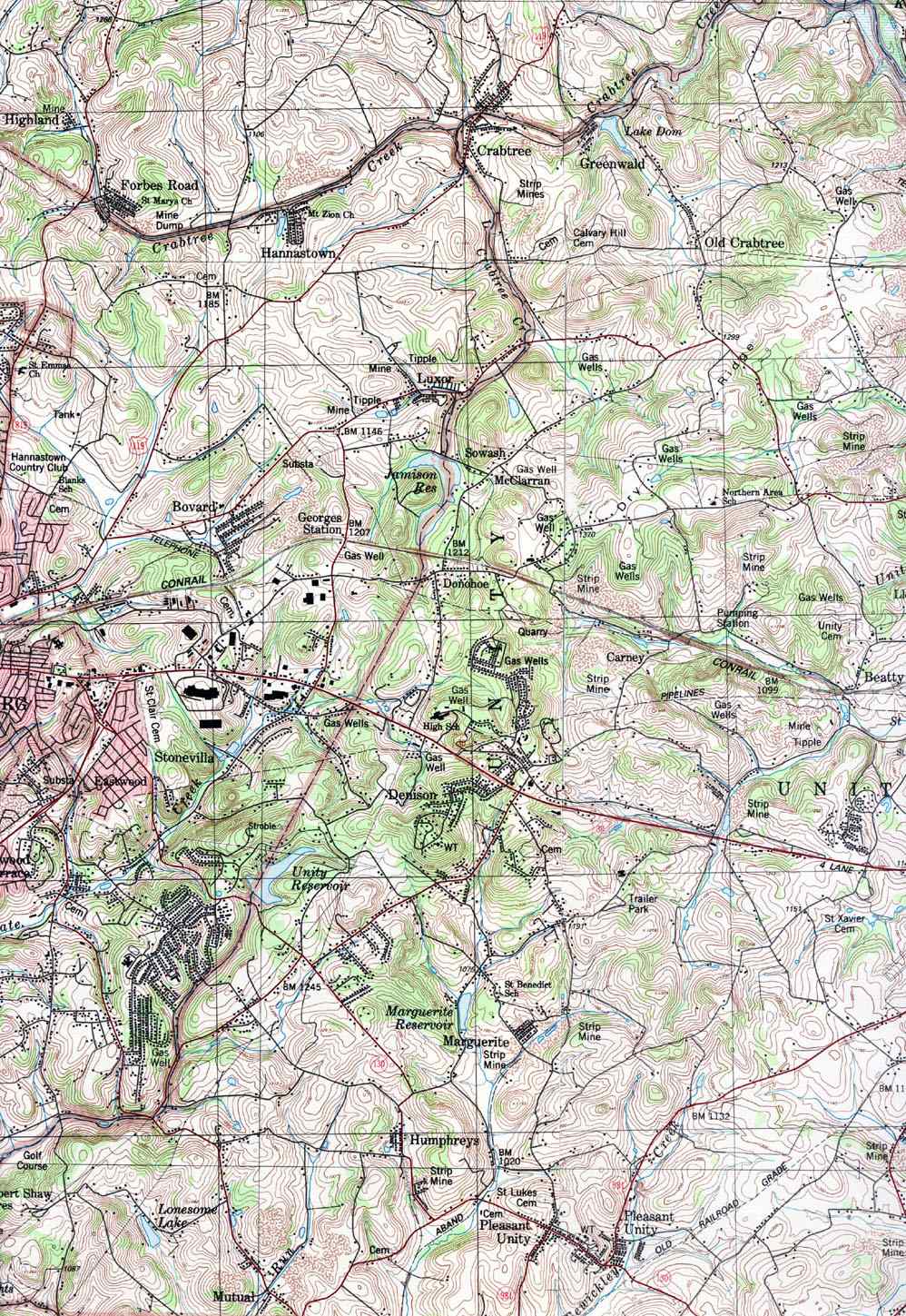
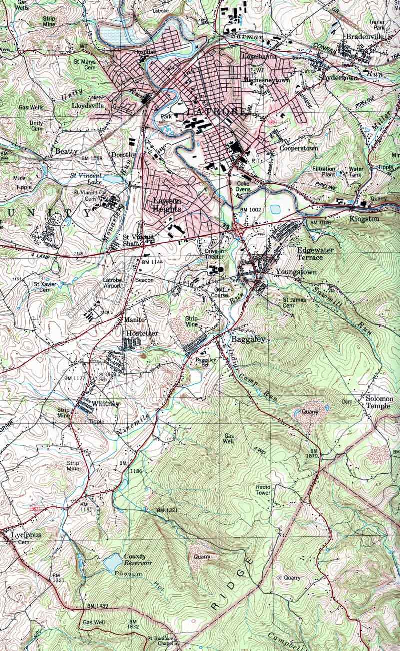
The township contains the following communities: Baggaley, Beatty, Carney, Denison, Donohoe, Dorothy, Dry Ridge, George's Station, Greenwald, Hostetter, Humphreys, [[Lawson Heights, Pennsylvania|Lawson Heights]], [[Lloydsville, Pennsylvania|Lloydsville]], Lycippus, Manito, Marguerite, Mutual, Old Crabtree, [[Pleasant Unity, Pennsylvania|Pleasant Unity]], and Whitney.<ref>{{cite web |title=2024 Fact Book - Neighborhoods |url=https://www.latrobebulletinnews.com/2024-fact-book---neighborhoods/article_949a0db2-9516-548b-b7a9-6d82317c457d.html |website=Latrobe Bulletin |access-date=1 May 2025}}</ref> To the west lies [[Hempfield Township, Westmoreland County, Pennsylvania|Hempfield Township]]; to the east, [[Latrobe, Pennsylvania|Latrobe Borough]] and [[Derry Township, Westmoreland County, Pennsylvania|Derry Township]]. | The township contains the following communities: Baggaley, Beatty, Carney, Denison, Donohoe, Dorothy, Dry Ridge, George's Station, Greenwald, Hostetter, Humphreys, [[Lawson Heights, Pennsylvania|Lawson Heights]], [[Lloydsville, Pennsylvania|Lloydsville]], Lycippus, Manito, Marguerite, Mutual, Old Crabtree, [[St. Vincent College, Pennsylvania|St. Vincent College]], [[Pleasant Unity, Pennsylvania|Pleasant Unity]], and Whitney.<ref>{{cite web |title=2024 Fact Book - Neighborhoods |url=https://www.latrobebulletinnews.com/2024-fact-book---neighborhoods/article_949a0db2-9516-548b-b7a9-6d82317c457d.html |website=Latrobe Bulletin |access-date=1 May 2025}}</ref> To the west lies [[Hempfield Township, Westmoreland County, Pennsylvania|Hempfield Township]]; to the east, [[Latrobe, Pennsylvania|Latrobe Borough]] and [[Derry Township, Westmoreland County, Pennsylvania|Derry Township]]. | ||
==Demographics== | ==Demographics== | ||
| Line 103: | Line 105: | ||
|footnote=U.S. Decennial Census<ref name="DecennialCensus">{{cite web|url=https://www.census.gov/programs-surveys/decennial-census.html|title=Census of Population and Housing|publisher=Census.gov|access-date=June 4, 2016}}</ref><ref>{{Cite web | url=https://www.census.gov/prod/cen1990/cph2/cph-2-40.pdf | title=1990 Census of Population and Housing - Unit Counts Pennsylvania | archive-url=https://web.archive.org/web/20211108173918/https://www.census.gov/prod/cen1990/cph2/cph-2-40.pdf | archive-date=2021-11-08}}</ref><ref>{{Cite web | url=https://www2.census.gov/prod2/decennial/documents/17216604v1p40ch02.pdf | title=Number of Inhabitants - Pennsylvania}}</ref> | |footnote=U.S. Decennial Census<ref name="DecennialCensus">{{cite web|url=https://www.census.gov/programs-surveys/decennial-census.html|title=Census of Population and Housing|publisher=Census.gov|access-date=June 4, 2016}}</ref><ref>{{Cite web | url=https://www.census.gov/prod/cen1990/cph2/cph-2-40.pdf | title=1990 Census of Population and Housing - Unit Counts Pennsylvania | archive-url=https://web.archive.org/web/20211108173918/https://www.census.gov/prod/cen1990/cph2/cph-2-40.pdf | archive-date=2021-11-08}}</ref><ref>{{Cite web | url=https://www2.census.gov/prod2/decennial/documents/17216604v1p40ch02.pdf | title=Number of Inhabitants - Pennsylvania}}</ref> | ||
}} | }} | ||
At the [[2000 United States | At the [[2000 United States census|2000 census]] there were 21,137 people, 7,963 households, and 5,773 families living in the township. The population density was {{convert|315.0|PD/sqmi|PD/km2|sp=us|adj=off}}. There were 8,372 housing units at an average density of {{convert|124.8|/mi2|/km2|disp=preunit|units |units|}}. The [[Race and ethnicity in the United States Census#2000 census|racial makeup]] of the township was 98.12% White, 0.32% African American, 0.13% Native American, 0.86% Asian, 0.02% Pacific Islander, 0.15% from other races, and 0.40% from two or more races. Hispanic or Latino people of any race were 0.42%.<ref name="GR2">{{cite web|url=https://www.census.gov |publisher=[[United States Census Bureau]] |access-date=January 31, 2008 |title=U.S. Census website }}</ref> | ||
Of the 7,963 households 29.5% had children under the age of 18 living with them, 61.9% were married couples living together, 7.5% had a female householder with no husband present, and 27.5% were non-families. 24.6% of households were one person and 11.4% were one person aged 65 or older. The average household size was 2.48 and the average family size was 2.95. | Of the 7,963 households 29.5% had children under the age of 18 living with them, 61.9% were married couples living together, 7.5% had a female householder with no husband present, and 27.5% were non-families. 24.6% of households were one person and 11.4% were one person aged 65 or older. The average household size was 2.48 and the average family size was 2.95. | ||
Latest revision as of 07:23, 8 October 2025
Template:Short description Template:Use mdy dates Template:Use American English Template:Main otherScript error: No such module "Infobox".Template:Template otherScript error: No such module "Check for unknown parameters".Script error: No such module "Check for clobbered parameters".Template:Main other
Unity Township is a township in Westmoreland County, Pennsylvania, United States. The population was 21,724 at the 2020 census,[1] a decline of approximately 4% compared to the 2010 census.
The township is home to Arnold Palmer Regional Airport. The Norfolk Southern Railway (once part of the Pennsylvania Railroad mainline) runs through the northern section of the township.[2]
History
Unity Township was incorporated on September 23, 1789. Initial records show settlement going back to 1760. Residents of Mount Pleasant Township petitioned the court to establish a new township around the area next to the Loyalhanna creek, based on the inconveniently large size of the existing township, which made it necessary to travel long distances to conduct township affairs. One of the oldest communities in the township was Youngstown, an important stop in the wagon and stagecoach era, ca. 1818–1852, which became a separate borough in 1831.[3]
The township is home to Unity Cemetery, which was established in 1774.[4] Some 15,000 people are believed to buried in the cemetery,[5] including Colonel John Proctor,[6] 31 other Revolutionary War veterans, U.S. Congressman William Findley[7] and television host Fred Rogers.
In 1847 the Sisters of Mercy, an Irish Catholic order, established St. Xavier's Academy for Girls in Unity.[8] In time, it expanded to include a convent. The buildings were destroyed by a fire in 1972, but the sisters' cemetery on the former school grounds in Unity remains.[9][10][11]
For a time the coal industry "dwarfed all others" in the township, according to historian John Boucher, writing in 1906.[12] Mines which once operated in Unity Township included those named Carney, Humphries, Dorothy, Marguerite, Mutual, Puritan (in Baggaley), Whitney, Jamison No. 20 (in Pleasant Unity), Hostetter, Beatty and St. Vincent's Shaft. Many of them were constructed in the period 1880 to 1900. All have long since closed. Extensive land remediation has taken place and few traces of the mines remain, but their names survive in township neighborhoods and streets.[13][14][15][16][17][18]
Carr's Tunnel, an abandoned railroad tunnel, is located in Unity Township. Locally known as Witches' Tunnel, it is on a now-dismantled spur of the Pennsylvania Railroad which serviced coal mines in the area, including the Carney mine.[19]
The Kingston House and St. Vincent Archabbey Gristmill are listed on the National Register of Historic Places.[20]
Geography
According to the United States Census Bureau, the township has a total area of 67.3 square miles (174.2 km2), of which 67.1 square miles (173.8 km2) is land and 0.2 square mile (0.4 km2) (0.24%) is water.
The township contains the following communities: Baggaley, Beatty, Carney, Denison, Donohoe, Dorothy, Dry Ridge, George's Station, Greenwald, Hostetter, Humphreys, Lawson Heights, Lloydsville, Lycippus, Manito, Marguerite, Mutual, Old Crabtree, St. Vincent College, Pleasant Unity, and Whitney.[21] To the west lies Hempfield Township; to the east, Latrobe Borough and Derry Township.
Demographics
Template:US Census population At the 2000 census there were 21,137 people, 7,963 households, and 5,773 families living in the township. The population density was Template:Convert. There were 8,372 housing units at an average density of Template:Convert. The racial makeup of the township was 98.12% White, 0.32% African American, 0.13% Native American, 0.86% Asian, 0.02% Pacific Islander, 0.15% from other races, and 0.40% from two or more races. Hispanic or Latino people of any race were 0.42%.[22]
Of the 7,963 households 29.5% had children under the age of 18 living with them, 61.9% were married couples living together, 7.5% had a female householder with no husband present, and 27.5% were non-families. 24.6% of households were one person and 11.4% were one person aged 65 or older. The average household size was 2.48 and the average family size was 2.95.
The age distribution was 21.5% under the age of 18, 9.1% from 18 to 24, 26.4% from 25 to 44, 25.8% from 45 to 64, and 17.2% 65 or older. The median age was 41 years. For every 100 females, there were 96.7 males. For every 100 females age 18 and over, there were 93.6 males.
The median household income was $40,585 and the median family income was $49,593. Males had a median income of $37,907 versus $26,164 for females. The per capita income for the township was $21,116. About 5.8% of families and 8.7% of the population were below the poverty line, including 10.0% of those under age 18 and 9.8% of those age 65 or over.
Notable people
- William Findley, U.S. Congressman, 1791–1797
- John Latta (1836–1913), 1st Lieutenant Governor of Pennsylvania
Gallery
-
View from Unity Cemetery towards Chestnut Ridge
-
Historic graves in Unity Cemetery
-
Kingston (Johnston) House, National Register of Historic Places
-
Remediated coal mine site
-
Carr's (Witches') Tunnel
-
1940 Census description of township boundaries and St. Xavier's
_Tunnel_in_2013_02.JPG)
References
- ↑ Cite error: Invalid
<ref>tag; no text was provided for refs namedUSCensusEst2020-2021 - ↑ Script error: No such module "citation/CS1".
- ↑ History of Westmoreland County Volume 1, Chapter 41
- ↑ Script error: No such module "citation/CS1".
- ↑ Script error: No such module "citation/CS1".
- ↑ Script error: No such module "citation/CS1".
- ↑ Script error: No such module "citation/CS1".
- ↑ Script error: No such module "citation/CS1".
- ↑ Script error: No such module "citation/CS1".
- ↑ Script error: No such module "citation/CS1".
- ↑ Script error: No such module "citation/CS1".
- ↑ Script error: No such module "citation/CS1".
- ↑ Script error: No such module "citation/CS1".
- ↑ Script error: No such module "citation/CS1".
- ↑ Script error: No such module "citation/CS1".
- ↑ Script error: No such module "citation/CS1".
- ↑ Script error: No such module "citation/CS1".
- ↑ Script error: No such module "citation/CS1".
- ↑ Script error: No such module "citation/CS1".
- ↑ Template:NRISref
- ↑ Script error: No such module "citation/CS1".
- ↑ Script error: No such module "citation/CS1".
External links
- Unity Township official site
- USGS Geological Survey Map of Unity Township dated 1987. Identifies neighborhoods, former mine sites.
Template:Pittsburgh Metro Area Template:US county navigation box